The December 2004 Sumatra – Andaman Earthquake and the Impacts of Indian Ocean Tsunami on Sri Lanka.
Part I: Tsunami Earthquakes.
Ananda Moonasingha
Introduction
The Sumatra-Andaman earthquake on 26 December 2004 is the second largest and generated the most devastating tsunami in the recorded history. The real-time seismic monitoring measured a moment magnitude of 9 and subsequent studies using very long period waves determined a moment magnitude of 9.3. The total death toll was in the order of 300,000. Indonesia and Sri Lanka are the most severely affected countries by the tsunami. The tsunami was generated by a rare mega earthquake that occurs in a subduction zone fault line. Tsunamis are long wave length, small amplitude waves in the deep ocean hydrodynamically called shallow water wave, and when shoal in the continental shelf, increase the wave height tremendously to inflict savage destruction by inundating the coastline. In spite of Sumatra-Andaman active fault line there are no records of destructive tsunami in the Indian Ocean in modern history. Therefore prior to December 2004 a formal tsunami warning system did not exist in the Indian Ocean. This paper is written in two parts. The part I presents the concepts and fundamentals of seismology and tsunami. The part II presents an overview of the December 2004 Sumatra-Andaman fault rupture, the ensuing Indian Ocean tsunami and consequent tsunami preparedness of Sri Lanka.
Tsunamis are caused primarily by displacement of seabed from submarine or coastal earthquakes. Other sources of tsunamis are undersea or coastal eruption of volcanoes or landslides that could displace enormous volume of water. Tsunami is a Japanese word meaning harbour wave. An earthquake that can generate tsunami is known as tsunamigenic or tsunami earthquake. Tsunamis are principally generated by undersea shallow earthquakes of magnitude greater than 6.5 on the Richter scale (Crawford, US Army). In the Nicaraguan earthquake in September 1992 there was an alarming disparity between the low body wave magnitude Mb = 5.3 and size of the tsunamis generated (Okal, Nat 686). Earthquakes with foci from 70 to 300 km deep are called intermediate focus and those are deeper than 300 km are termed deep focus. The depth less than 70 km is shallow (Bolt).
There have been 4 large earthquakes of magnitude 9 or more in the latter half of 20th century. These were all tsunamigenic and of these the great Chilean earthquake in March 1960 of magnitude 9.5 is the biggest recorded earthquake. These great earthquakes occur where large subduction oceanic tectonic plates underthrust the continental plates along a subduction fault. These are known as megathrust earthquakes. The (Fig. 1) depicts the regional plate tectonic system containing Sumatra-Andaman fault and the Indo-Australian Plate (Chp 1 of Tsunami by weber-Andaman.org). The intermediate microplate is known as the Burma or Andaman microplate (Lay et al Sci 1128). Historic great earthquakes have occurred along this plate boundary in 1797 (M~8.4), 1833 (M~9) and in 1861 (M~8.5) (Lay et al Sci 1128). The latter two are estimated to have generated tsunamis 5 to 10 m high (Bilham Sci 1126).
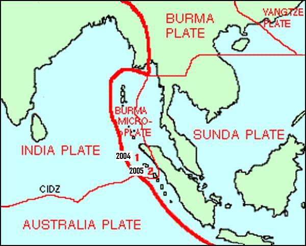
http://www.andaman.org/mapstsunami/tsunami.htm
Fig. 1. Plate Tectonics of Sumatra-Andaman Fault Region.
Island Arcs
The geomorphology of subduction trench can be briefly described using schematic of island arc illustrated in (Fig.2) (Weber). an island arc is a tectonic belt of high seismic activity bordered by a submarine trench. It forms where a plate of oceanic lithosphere collides with and is subducted beneath another oceanic plate or continental crust along a subduction zone which extends to about 700 km depth and is the focus of shallow to deep earthquakes (Windley EvCon). There are several types of island arcs. Andaman islands, Sumatra and Java are island arcs (Windley).
The two tectonic plates constantly converge at different rates per year in different subduction zones accumulating stress in the crustal rocks due to friction in the fault interface. At a critical level of stress the rock will rupture initiating an earthquake along the faultline. This mechanism is known as the elastic rebound theory. Releasing the stress in the focus seems to abet propagation of the rupture by increasing the stress in adjoining length of the fault. This hypothesis is a premise for the occurrence of earthquakes in contiguous segment of a faultline subsequent to a major earthquake (Li & Kisslinger, Eartq Predict). For example the earthquakes in March 2005 and July 2006 in the Sumatra and Java trenches following the December 2004 earthquake ( McCloskey et al Nat 291, Hopkin Nat 547, Nalbant et al Nat 756).
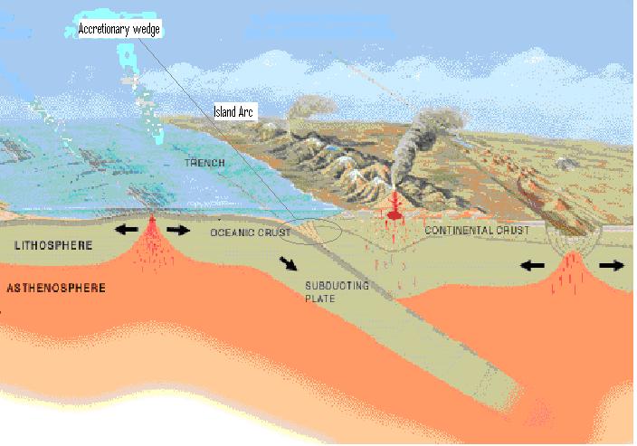
Fig. 2. Geomorphology of Subduction Zone Island Arc:
Trench with Accretionary Wedge
Tsunami Source Mechanism
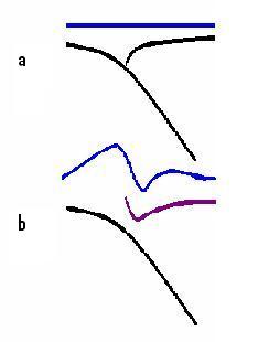
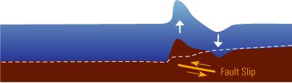
Fig. 3. Schematics of Tsunami Source Mechanism
Schematically as depicted in (Fig. 3) during long-term convergence the outer edge of arc island plate is compressed downward (USGS). During the rupture if it propagates to the top of the fault plane the depressed tip bounces upward. Simultaneously the outer arc ridge subsides to a trough. The seabed and water column above undergo displacement congruent to the uplift and depression of the arc crust thereby generating a tsunami wave. On this illustration the elevation wave generates to the left or westward and depression wave propagates to the east as was the evolution source of tsunami waves on the 26 December 2004. (Dalrymple et al Oceano p 142, Japanese analysis Preface 28 Jan. Rabinovich & Thomson Pure Apply geophysi, Commer – Tsunamis p77-92). The dynamics of deformation of the seabed and acoustic effects of the seawater column affect the tsunami amplitude in the near-field and arrival times of tsunami in the far-field (Ohmachi et al. Bull of Seism Soc of America Dec 01).
Sedimentary Structures
The accretionary wedge or prism in the subduction trench is an important feature that contributes different impacts on the tsunami excitation (Fig. 2). Oceanic sediments accumulate in the subduction trench. The converging movement of the subduction plate pushes some of the sedimentary materials into the subduction interface. Presence of large amount of sedimentary materials in the trench scrape–off to create an accretionary wedge in the mouth of the subduction zone (Windley EvCon).
On the one hand the presence of large amount of sediment may mitigate the tsunami excitation by preventing the rupture propagating up to the ocean floor. On the other hand sedimentary structures can slowdown the rupture, there by enhancing the tsunami generation. Model analysis suggests where moment release takes place in the sediments with weaker elastic properties the tsunami magnitude is higher than its seismic moment would suggest (Okal 9 March Nat Haz, Nat 686, Seno & Hirata 15 Feb). entrapped layers with lower rigidity cause greater slip for a given seismic moment (Synolakis Nat 597, Seno & Hirata 15 Feb). A large earthquake can cause sedimentary structure to slump exciting a tsunami (Okal Nat 687). Occasional slumping of the accretionary prism may cause sedimentary structure to slump exciting a tsunami (Kanamori Nat 716).
Where the sediments are sparse and soft material is subducted into the plate interface the slip can extend to the surface creating the conditions for tsunami excitation (Kanamori Nat 716). In the 1992 Nicaragua tsunami earthquake, because of the absence of sediments on trench floor, the slip propagated up-dip all the way to the ocean floor exciting large tsunamis. The occurrence of slip on a plate interface filled with soft subducted sediments caused the rupture process to be slower than in ordinary subduction zone thrust earthquakes (Kanamori Nat 715).
Subduction of younger lithosphere tends to result in interplate faults with shallow dips and broad contact areas that generate giant earthquakes, whereas in locations where older lithosphere is subducted and back-arc spreading is observed great earthquakes are rare. The age of subducting oceanic plate between Sumatra and Andaman Islands increases from about 60 million years (Lay & Kanamori et al Sci1132). About half the subduction zones with excess trench sediments are characterised by occurrence of great earthquakes. Most of other zones with excess trench sediments but without great earthquakes are predicted to have small earthquakes by age-rate correlation (L.J.Ruff).
Tsunamigenic Earthquakes
Dip-slip rather than strike slip, magnitude of seafloor displacement, primarily vertical motion and its aerial extent are key parameters that determine tsunami potential (Kanamori & Given – Tsunamis, Crawford –US Army). Other prominent characteristics of tsunamigenic earthquakes are slow faulting motion, very long rupture duration, extending all the way up to the ocean floor, and shallow focus (Synolakis Sci 599, Kanamori Nat 716). An important distinguishing feature of tsunami earthquake is much larger moment magnitude Mw determined from long-period surface waves than the Richter magnitude Ms determined from 20s surface waves (Kanamori Nat 714). In the Nicaragua tsunami earthquake the moment magnitude Mw=7.6 determined from long period 250 sec surface waves was significantly larger than 20s Ms of 7 (Kanamori Nat 714). Shallow dip thrusting along the plate interface is the very likely mode of most tsunamigenic earthquakes. Steep thrusting in the sediments at the leading edge of overriding plate may occur in tsunamigenic earthquake, although it may have originated as shallow thrusting (Commer, Tsunamis P77-92). The (Fig. 4) illustrates a basic profile of the Sumatra-Andaman fault (Choi.R. 10 March).
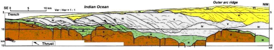
Fig. 4. Choi’s interpretation of a seismic profile across the Java Trench.
Earthquake Magnitude
The size or magnitude of an earthquake is generally expressed as Richter Scale introduced by Charles F.Richter in 1935. The Original Richter magnitude is a local scale ML. Richter defined the magnitude of a local earthquake as the log10 of the maximum seismic wave amplitude in micrometers recorded on a standard seismograph at a distance of 100 km from the earthquake epicentre. The definition of local magnitude ML was for Southern California earthquakes only using P, S body waves or surface waves (Bolt Earthqu).
ML= logA-2.48+2.76log∆ where A is amplitude in mm and ∆ is distance from the seismometer. ML can also be determined using a graphical solution incorporating the parameters A (mm), distance ∆ (km) and time (s) difference of secondary (S) and primary (P) waves (S-P) (Stein ISEES, Lay MGS).
The equation for surface wave magnitude is: (Stein ISEES, Lay MGS)
Ms=logA20+1.66log∆+2.0 where A20 is the amplitude of the 20s period surface wave in micrometers.
The above equations of magnitude are totally empirical and have no direct connection to the physics of earthquake. ML based on body waves of period 20s above about 8.3 suffer from the effect of magnitude saturation (Stein ISEES, Okal Nat 686). The amplitude of seismic waves represents the energy released from a volume of crustal rock whose representative dimension is comparable to the wave length. Since the wave length of seismic waves used for the determination of Ms is only about 60 km, the amplitude of 20s waves does not increase as the fault length increases beyond 60 km. therefore the Ms scale saturates (Kanamori Nat 411). Energy in an elastic wave of given period is proportional to the square of the amplitude (Richter Elem Seism).
A relationship between magnitude of body waves and surface waves given by Richter is: m=2.5+0.63M or M=1.59m-3.97, where m and M are magnitudes derived from body and surface waves respectively (Richter Elem Seis). Magnitude related to energy released from the earthquake is given as: logE=5.8+2.4m. Since m=2.5+6.3M
logE=11.8+1.5M.
Guttenberg and Richter gave the relation for Ms:
logE=11.8+1.5Ms where energy E is in Ergs (Lay MGS, Kanamori Nat 411).
The seismic moment Mo based on elastic dislocation theory is a more reliable measure of the size of a large earthquake (Stein SIEES, Lay MGS, Kanamori Nat 412).
Mo=µDS where µ is the shear modulus or rigidity of fault material, D is average slip or dislocation, and S is rupture area of the fault. The new magnitude scale Mw called moment magnitude:
Mw= (logMo/1.5)-10.73 where Mo is in dyn. cm.
Because of the log scale of magnitude, an increase in each whole number represents a tenfold increase in real magnitude and indeed approximately 30 times increase in energy.
Modern methods of locating earthquakes differ in detail, but they essentially depend on single parameter: the travel time of a seismic wave such as a P wave from a source to a seismometer (Bolt Earthqua). Prior to instrumental recording, comparisons of earthquakes were based mainly on shaking damage and seismic intensity scales were developed based on varying levels of damage (Lay MGS). As shown in the Table 1, modified Mercalli intensity scale classifies the effects of shaking and damage into 12 Roman numeral grades in the ascending order (Stein ISEES).
Table 1. A summary of modified Mercalli intensity scale.
Intensity Effect
I Shaking not felt, no damage.
II Weak shaking felt slightly by few, no damage.
III Felt noticeably.
IV Light shaking, no damage.
V Moderate shaking, no damage.
VI Strong shaking, light damage.
VII Very strong shaking, moderate damage.
VIII Severe shaking, moderate to heavy damage.
IX Violent shaking, heavy damage, ground badly cracked.
X Extreme shaking, very heavy damage, ground badly cracked.
XI Severe damage, broad fissures in ground.
X Total damage, waves seen on ground.
Forecasting Earthquakes
Earthquake prediction is defined as specifying within certain ranges the location, time and size of an earthquake a few years to days before it occurs (Bolt). Earthquake forecasting is classified into long-term, intermediate and short-term. Long-term is many years in advance. Intermediate and short-term are months to weeks, days or hours in advance.
One method of long-term forecasting is based on historical records of past events. The reliability of forecasting from historic records depends on the total number of events recorded and the length of recorded period in history (Bolt Earthq, Horikawa & Shuto, Tsunamis). The historic records of earthquakes may be available from written records, folklore, paleoseismic, paleogeodetic and paleotsunami studies. The most rudimentary statistical method to estimate the return interval (T) is to divide the length of historical period of records (N) years by the number of earthquakes (n) occurred within that period (T=N/n). This return period is associated with a probability factor (Bolt, Stein ISEES, Gray, U of Wiscon). A more scientific method of long-term forecasting of earthquakes is based on the relation between the annual convergence rate of subduction tectonic plates and the average slip of the fault during a typical rupture.
If the convergence rate is V (m/yr), and the average slip is S (m), then the
Return period Tr (yrs) = S/V
Another category of earthquake predicting consists of a broad range of precursory phenomena or various geophysical studies suggesting seismic behaviour (Lay MGS, Gray, U of Wiscon, Shimazaki-Earthq prediction). Some of the premonitory phenomena studied for earthquake prediction include: ground movement, strain-stress in active faults, foreshocks, seismicity, conductivity, geoelectricity and animal behaviour. These are mostly intermediate and short-term prediction techniques. Of the precursory techniques co-seismic and post-seismic strain-stress studies are a scientific method that has performed approximately but adequately reliable prediction of impending earthquakes since the December 2004 earthquake in the Sumatra-Andaman fault (McCloskey Nature 434-291, Nalbant nat 435-756).
Forecasting Tsunamis
Long-term forecasting of tsunamis is similar to forecasting earthquakes. Long-term to short-term forecasting techniques are applied to potential submarine earthquakes. The real-time initial warning and assessment of a potential tsunami is based on the magnitude and location of focus of a submarine or coastal earthquake. Modern earthquake monitoring is semi-automated with computers and broadband technology. Tsunami waves of few mm amplitude in the deep ocean can be measured and transmitted by state-of-the-art instrumentation like tsunameters. The tsunameter consists of a bottom pressure recording sensor at the bottom of the sea and other telematic, acoustic, GPS data transmitting instruments mounted on a buoy (Bernard DTRC).The verification of tsunami warning begins when the tsunami height data transmitted by Deep Ocean Assessment and Reporting of Tsunami (DART) by a tsunameter or tide gauge nearest to the earthquake source is available to the tsunami monitoring and warning centres. Tsunameter data are more reliable than tide gauge data as tide gauge reading can be affected by harbour response and similar coastal effects (Vasily, Titov & McGreery DTRC-NOAA). Tide gauge readings may take longer to reach the control centres.
The incoming wave data are iteratively analysed using forward and inversion techniques and linear computer models to match pre-computed best model scenario that fits the data. This process produces the estimates of forecast tsunami characteristics in deep ocean which can then be used to forecast the site specific inundation profiles on the coastline (Vasily Titov DTRC, Dalrymple, Oceanography). The above systems of real-time tsunami and coastal inundation forecasting are deployed in the socio-economically critical Pacific coast of America where the impacts of false tsunami warnings are considered seriously as the risks of tsunami inundation. Less complex forward model forecast can be obtained within few minutes (DTRS). Japan is developing bottom pressure gauges, cabled instruments and digital tide gauges for tsunami warning (Baba, Hirata et al AGU, Mikada, Hirata et al IEEE, Kato et al ITS)
Similar to earthquakes, forecasting of tsunamis is not an exact science. However the image of tsunami warning systems and its credibility is good and has improved (Pararas Tsunamis). This view is based on the performance of tsunami forecasting in the Pacific Ocean where the tsunami hazard frequency is high and therefore most efforts in hazard management in the world have been concentrated upon. Corollary of this fact the obvious unawareness and unpreparedness of very low frequency mega-tsunami hazard management of the December 2004 Indian Ocean tsunami is echoed.
Tsunami Waves
Unlike wind generated waves, tsunamis are a type of low-frequency, long period, long wave length small amplitude waves in deep ocean. The wave period in general can be 200-3000s and the wave length from tens of (km) to hundreds of (km). The small amplitude is few (cm) to 10 m in relation to the wave length and ocean depth (Sorensen-Basic coastal eng. Lay MGS. Stein, ISEES). Tsunamis in deep ocean can travel at speed of 300-600 mph (Keim Oceanog p44). Depth of Indian Ocean is 3-4 km.
Wind generated waves in deep water contain most of their energy near the surface. In contrast tsunami generated by submarine earthquakes or similar large impacts contain the energy flow in the entire water column. Because the kinetic energy of a tsunami is evenly distributed throughout its entire depth, when it reaches the continental shelf and approaches the shore, its wave height increases tremendously by converting kinetic energy to potential energy (Yeh, Liu et al Nat 354). Shoaling tsunami similar to wind generated waves is a gravity wave because gravity is the main restoring force in the system with gravitational energy making up more than 95 percent of the energy in wave run-up (Lay MGS p149). The kinetic energy previously spread throughout a large volume of deep ocean water becomes concentrated to a much smaller volume of water resulting in a tremendous destruction potential as it inundates the land (Keim Oceanograp p44).
Large cross-fault width of seafloor deformation of tsunamigenic earthquakes generates similarly long wave lengths of tens or hundreds of km of initial waves much greater than ocean depths (Dalrymple Oceano 143). Two main factors affecting tsunami wave directionality are: the focusing configuration of the source region and the waveguide structure of midocean ridges. In the near field, focusing effect of large extension of the earthquake source region was the primary factor determining directionality of the December 2004 Indian Ocean tsunami. The long and narrow initial sea floor deformation generated waves with highest amplitudes propagating in the cross-source direction, with smaller energy waves propagating in the long-source (meridianal) direction ( Titov et al Sc p2047, Crawford US Army).
Paths of tsunami deviate from the shortest great circle path if there are large lateral velocity variations due to changes in seafloor topography. This effect known as multipathing induces tsunami waves to arrive at a coastal region from several directions that can result in changes in wave amplitudes due to the effects of focusing and defocusing (Stein ISEES p100).Multipathing is a wave directional phenomenon comparable to diffraction, scattering and refraction. Another focusing effect is wave directionality towards antipode (Lay MGS p94).
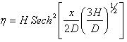
The run-up of tsunami on the shoreline depends on the schooling history of the waves, the local bathymetry and topography, nature of any underwater canyons, coastal structures and shoreline features. A high-cliffed coastline would likely to mitigate the tsunami hazards (Dalrymple Oceanog). A coastline with a shallow gradient or flat plane will experience a long inundation distance. An example is the area of Mulative in the north east of Sri Lanka. Coastal features such as bays, lagoons, harbours and estuaries can cause resonance. Openings through dunes and coral reefs act as a conduit causing jetting and inundation damage (Fernando et al Calgary, Liu et al Sci 1595, Crawford US Army). Both runup and return flow cause damage. As shown in (Fig. 5) the tsunami inundation is the maximum horizontal intrusion inland from the initial coastline. The run-up is the height at the maximum inundation point (Post tsunami survey field guide UNESCO).
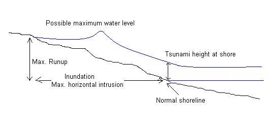
Fig. 5. Tsunami Inundation.
Tsunami Magnitude
There are several citations of relationships of tsunami magnitude (Horikawa & Shuto Tsunamis). Abe has given the expression: (Abe.K. Phys Earth Planet Inter)
Tsunami magnitude Mt = logH2+logX+5.55 where H2=Maximum crest to trough amplitude on tide gauge record in (m). X=Distance from epicentre to station along the shortest oceanic path in (km). He also suggests, given the value of Mt the run-up height at near-source distance can be estimated from the relation: (Abe J.Seism.Japan)
Mt=2logHm+6.6 where Hm is the maximum value of the local-mean run-up height in (m) and the logarithmic mean of heights is taken over a distance of about 40km along the coast.
Tentative Tsunami Intensity Scale
The 12-point scale of tsunami intensity proposed in 2001 by Gerassimos Papadopoulos and Fumihiko Imamura is arranged according to tsunami effects on humans, on objects such as boats and damage to buildings. (About.com Geology)
I Not felt
II Scarcely felt.
III Weak
IV Largely observed.
V Strong (wave height 1m).
VI Slightly damaging (2m).
VII Damaging (4m).
VIII Heavily damaging (4m).
IX Destructive (8m).
X Very destructive (8m).
XI Devastating (16m).
X Completely devastating (32m).
Modelling
Modelling of earthquake source is performed by analysing direct measurements of various wave forms and by inversion of seismograph records. Inversion is the process of back tracking the travel times and characteristics of wave forms obtained on seismographs to create an image of the source mechanism that produced the initial wave forms to unravel the physical process of its source. Based on partial parametric assumptions a seismic model is described and the available data are applied to estimate the earthquake parameters consistent with the data obtained from the seismogram. Best fit inversion is achieved by trial and error or applying numerical techniques (Stein ISEES). Subduction fault zone geology is extremely heterogeneous, making accurate modelling difficult, resulting in large uncertainty in estimated ground deformation (Synolakis and Liu Sci 599, Ammon & Ji Sci 1133). For the source mechanism of tsunamigenic subduction zone earthquakes more uncertainties are implicated in the trench morphology and rupture characteristics especially ascribed to trench sediments.
Two main areas of tsunami research are inversion models of tsunami propagation and wave run-up on beach. Inversion of tsunami wave data measured by tsunameters, satellite altimeters and tide gauges enable profiling the tsunami source mechanism. The accuracy of model forecasting of inundation run-up depends not least on the depiction of bathymetry and topographical details of the coastline. The interaction of wave run-up with the fixed obstacles and the mass of debris of trees, vehicles, boats and houses carried in the tsunami run-up is not considered in the inundation run-up model analysis (Dalrymple Oceano). Different models based on different techniques and parametric assumptions thus produce slightly different results (Lay & Kanamori Sci 1130, Ammon & Ji Sci 1133-39, Seno & Hirata 15 Feb, Titov DTRC, Dalrymple Oceano). By careful formulation of the ball accelerations of tsunami energy, both wave-like and flood-like behaviors are accommodated so tsunami waves can be run seamlessly from deepwater, through wave breaking, to the final surge onto shore and back again (Ward and Day). In modeling several 2-D and 3-D cases, Ward and Day found that wave breaking generally causes relative runup to increase with beach slope and wave period and decrease with input wave amplitude.
Satellite Altimetry
Radar altimeters on-board satellites improve the tsunami modelling. But the paths of satellite altimeters over the propagating tsunamis are fortuitous and may take hours to days after the real-time for the satellite altimeter data to reach the tsunami monitoring centres. Hence satellite altimeter data cannot be relied upon for real-time forecasting. However the data available from satellite altimeters are extensively used for post-tsunami research including inversion model investigations (Smith - Oceano, Seno & Hirata 15 Feb).
Post-tsunami model analysis using different parametric assumptions of fault geometry, waveforms and techniques have been performed to predict seismic moment Mo, slip, rupture duration, and speed of faulting. These reports illustrate how the different input assumptions and analytical methods affect the consistency of analysis (Synolaki et al Sci 599 Ammon et al Sci 1133, Titov et al Sci 2045,).
Linear Wave theory
Theory of wave analysis constitutes basically linear and nonlinear models. The small amplitude theory follows the linear wave theory presented by Airy in 1845, which assumes the amplitude is small compared to the length and other simplifications of wave characteristics and approximations ignoring the 2nd order component of the equation (Sorensen Basic Coastal Eng, McCormick Ocean Eng wave Mech). For long waves, linearity is assumed by the fact that the ratio of water surface displacement to water depth is small (Titov DTRC, Dalrymple Oceanog). The derivation of the linear theory of wave analysis finally describes the celerity in the following equation (Sorensen Basic Coast Eng).
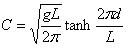
where g = acceleration due to gravity, L=wave length, and d=depth of water from the still water level. At long periods where the wave lengths are much greater than the ocean depth (d) the phase velocities are essentially nondispersive and is given by the so-called shallow water equation (Stein ISEES, Sorensen Basic Coast Eng, Dalrymple Oceanog, Satake, cia-igp). Shallow water equation applies from the condition where the relative water depth d/L is less than 0.5 (Sorenson, Basic Coastal Eng).

Thus tsunami velocities depend on ocean depth. However at shorter periods where the wave lengths are much less than the ocean depth the tsunami velocities depend on wave length as: (Stein ISEES, Lay MGS).

Waves at sea generally are complex combination of 2 or more trains superimposed on each other resulting in a wave group of which individual phase has a different amplitude and celerity to that of the wave group (Sorensen BCE p8). Tsunami waves are considered to be nondispersive until they shoal near the coastline (Lay MGS). Dispersing causes the waves with higher periods of wavelength to travel faster than the waves of lower periods (Stein ISEES, Lay MGS, Dalrymple Oceanog 145)
Nonlinearity
As much as the linear wave theory is recognized for analysis of tsunami waves in the ocean, nonlinearity of shoaling wave and run-up is acknowledged (Dalrymple Oceanog). Case studies of behaviour of tsunamis over real bathymetry and some laboratory studies suggest linear nondispersive equations are appropriate for the analysis of wave propagation and run-up on beach (Crawford US Army, Synolakis Nat Haz 1991 p221).
As the tsunami waves shoal induced by the coastal bathymetry they undergo significant changes in their characteristics. The most significant of these is increasing wave height. The constantly changing profile of wave forms and particle velocities of the tsunami may be described as rising, breaking, non-breaking, wall, bore and surging render the solution nonlinear (Titov DTRC, Heller et al J. Hydraulic Eng ASCE Sept 2005), Yeh Nat Haz 1991). This form of propagation of wave is modelled with nonlinear shallow water equations, which also forms the basis of the study of unsteady open channel hydraulics (Dalrymple Oceanog). Nonlinear shallow water models have been investigated by many others for example: Synolakis (1987), Maiti & Sen (1999), Gedik, Irtem and Kabdasli (2005), Wei, Kirby, Grilli et al (1995), Kirkgoz (1981).
Tsunami run-up of shoaling wave is usually idealised as a cnoidal or solitary wave. Various numerical and experimental models with varying degrees of simplification of nonlinearity have been studied (Camfield & Street ASCE, Li & Raichlen,. ASCE, Titov & Synolaki et al ASCE).
The Ursell number (U) is used as a guide to separate the two types of wave theory, Stoke’s or small finite-amplitude waves and cnoidal waves; and is defined as: (Camfild ASCE)
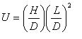
where H-the wave height above still water, D=the still water depth, and L= the wave length. When U<100 the waves are analysed using Stoke’s theory where nonlinearity and dispersion is ignored. When U> 100 cnoidal or solitary waves occur. Solitary wave is a maximum limit of the cnoidal wave when L is ∞.
Lord Rayleigh (1876) obtained the expression for celerity C of a solitary wave shown in Fig. (5) as: (Camfield & Street ASCE)
Bousinesq obtained the expression for the profile of solitary waves (Fig. 5)(Camfield ICE)
Some of the modelling software in usage are based on nonlinear Bousinesq theory (Dalrymple, Oceanography).
Fig. 5. Definition sketch of Solitary wave.
Solitary Wave
As oscillatory waves travel into shallow water their length increase and crests tend to become separated. If the distance between crests is large enough each wave starts looking and behaving rather like a solitary wave. Therefore shoaling oscillatory waves close to breaking may be treated as solitary waves (Kirkgoz, Tsunamis p467-474).
Bagnold (1947) presented an account of simplifications and approximations imposed in the process of deriving a shoaling solitary wave without a trough from small amplitude wave train in the deep ocean. He suggested as the wave period is increased beyond a certain limiting value (Teff) the shoaling wave train tends to split up into a succession of solitary waves (Bagnald ICE J 1947). Kirkgoz (1981) has given a simplified solution of the original relation of the solitary wave period (Kirkgoz, Tsunamis 1981).
to a first approximation,  where H is wave height and (d) the shoaling water depth.
A longer shoaling continental shelf seems to increase the frequency of oscillating nodes of resonant peaks than a shorter continental shelf. As the depth ratio of  continental shelf depth (d) to deep ocean depth d0 decreases the magnitude of wave amplitude increases (Liu, Tsunamis). The (Fig. 6) depicts a shoaling solitary wave adopted from the model study of tsunami wave in the continental shelf in the south east coast of Sri Lanka (Horrillo, Kowalik Uni of Alasaka).
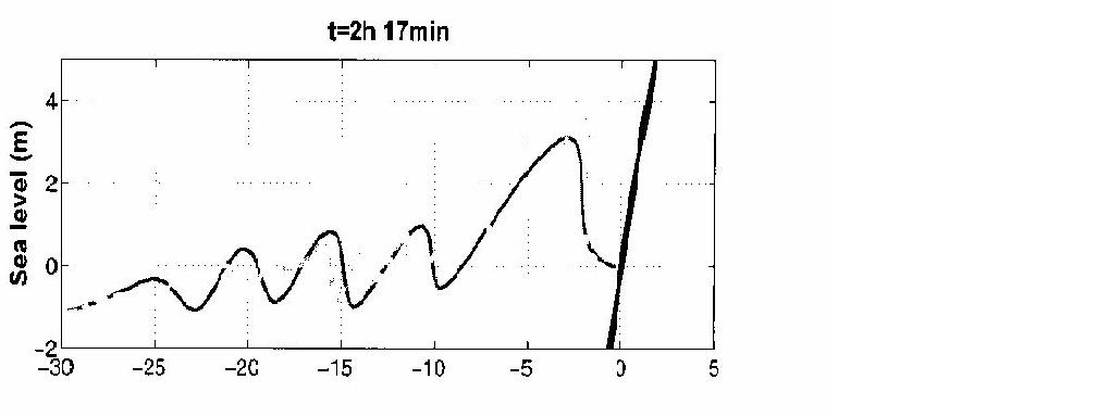
Fig. 6. Postulation of a Shoaling Solitary wave.
Summary
The December 2004 tsunami in the Indian Ocean was generated by a megathrust earthquake in the Sumatra-Andaman subduction zone fault. The earthquake mechanism is ascribed to elastic rebound theory of rupture by accumulated stress of the fault plane. The Sumatra fault is a dip slip reverse fault. The magnitude of earthquakes are commonly expressed as Richter Scale. Magnitude measured in Richter Scale using short period body and surface waves saturate beyond about magnitude 8. Hence, the moment magnitude based on elastic dislocation theory is used to measure the size of large earthquakes.
Methods of predicting large earthquakes are statistical analysis of historic records, estimates from convergence and slip rates, and medium to short-term precursory geophysical studies. Of these remote sensing of strain-stress in the fault zone has recently been proved most useful in the Sumatra fault.
Tsunamis are long wave small amplitude waves in the deep ocean, however defined as shallow water waves because of hydrodynamic relation of wave length to depth of ocean. When tsunami shoals on the continental shelf undergo profound changes in physical characteristics and tremendously increase in height accumulating destructive potential energy. Tsunami height at the coastline is dependent on the coastal bathymetry. Tsunamis in deep sea are analysed using linear wave theory. The tsunami wave runup is analysed as an idealised solitary wave using nonlinear equations. Earthquakes and tsunamis are studied using direct seismograms and waveform data, and by inversion of direct information. Earthquake fault zones re highly heterogeneous in geological composition and characteristics. Tsunami magnitude is also dependent on the characteristics of trench sediments that influence the sea bed rupture parameters. Earthquake and tsunami studies are based on simplified assumptions and conjectures facilitating satisfactory results. Real-time tsunami monitoring has been improved in recent times by Deep Ocean Assessment and Reporting of Tsunami (DART) using bottom pressure reading tsunameters and similar devices.
Acknowledgements
The author wishes to acknowledge initial discussions with Professors Nick Kusznir and Andreas Rietbrock of the University of Liverpool, online paper by Joe Fernando and others of University of Calgary, illustrations and maps and other online sources of papers and information used and cited in this paper.
References
Crawford.P.L., Tsunami Predictions for the Coast of Alaska Kodiak Island to Ketchikan. Department of the Army Corps of Engineers. Prepared for Federal Emergency Management Agency April 1987. Washington DC.
Okal.E.A., Predicting Large Tsunamis. Nature Vol 361 25 February 1993. p686-687.
Bolt.B.A. Earthquakes. W H Freeman & Co. 1998. New York.
Weber G. Chapter 1 of "Earthquake and Tsunami": Maps, Charts and Statistics. The Cause: moving geological plates
www.andaman.org/mapstsunami/1cause/1cause.htm
Lay. T., Kanamori.H., and Ammon.C.J. et al. The Great Sumatra-Andaman Earthquake of 26 December 2004. Science Vol 308 20 May 2005 p1127-1133.
Bilham.R., A Flying start, then a Slow Slip. Science, Vol 308, 20 May 2005. p 1126-1127.
Continental Drift and Plates Tectonics. Ellie Crystal’s Metaphysical and Science Website.
www.crystalinks.com/tectonicplates.html
Windley.B.F. The evolving Continents. John Wiley & Sons. 1995 Chichester.
Li.V.C. and Kisslinger.C. Stress transfer and nonlinear stress accumulation at subduction-type plate boundaries - Application to the Aleutians. Shimazaki.K. and Stuart.W. Editors. Earthquake Prediction. Birkhurst, 1985. Reprinted from Pure and Applied Geophysics. Vol. 122, No. 6, 1984/85.
McCloskey.J., Nalbant.S.S, and Steacy.S. Earthquake Risk from Co-seismic Stress. Nature, Vol. 434, 17 March 2005, p 291.
Hopkin.M. Indonesia Spared tsunami as Disaster Quake Strikes. Nature, Vol. 434, 31 March 2005. p 547
Nalbant.S.S., Steacy.S., et al. Earthquake Risk on the Sunda Trench. Nature, Vol. 435, June 2005, p 756-757.
USGS. Tsunamis and Earthquakes. http://walrus.wr.usgs.gov/tsunami/basics.html
Dalrymple, R.A., Grilli, S.T., and Kirby,J.T. Tsunamis and Challenges for Accurate Modelling. Oceanography. Vol. 19, No. 1 Mar 2006. pp 142-151.
Ward, S.N., and Day, S., Tsunami Balls: A Granular Approach to Tsunami Runup and Inundation. COMMUNICATIONS IN COMPUTATIONAL PHYSICS, Vol. 3, No. 1, pp. 222-249, January 2008. http://www.global-sci.com/freedownload/v3_222.pdf
Yoshiaki Kawata et al, Kyoto University. Comprehensive analysis of the damage and its impact on coastal zones by the 2004 Indian Ocean tsunami disaster.www.tsunami.civil.tohoku.ac.jp/sumatra2004/report.html 28 Jan 07
Rabinovich, A.B. and Thomson, R.E. The 26 December 2004 Sumatra Tsunami: Analysis of Tide Gauge Data from the World Ocean Part 1. Indian Ocean and South Africa. Pure and Applied Geophysics. 164 (2007) 261-308, Birkhauser Verlag, Basel. www.pac.dfo-mpo.gc.ca/sci/osap/publ/online/PAG2007_Rabinovich_Thomson261.pdf
Commer.P. Tsunami Eartquakes and Undersea Deformation p 77-92. Tsunamis: Their Science and Engineering. Edited by Iida.K. and Iwasaki.T. Proceedings of the International Tsunami Symposium 1981, pp 77-89. IUGG Tsunami Commission, May 1981, Japan. Terra Scientific Publishing Company (TERRAPUB) Tokyo, REIDEL 1983 London.
Ohmachi.T. et al. Simulation of Tsunami Induced by Dynamic Displacement of Seabed due to Seismic Faulting. Bulletin of the Seismological Society of America. Vol 91, No. 6 December 2001 pp 1898-1909
Okal.E.A. Seismic Parameters Controlling Far-field Tsunami Amplitudes. Natural Hazards. Vol. 1, No. 1, March 1988. p67-96
Okal.E.A. Predicting Large Tsunamis. Nature, Vol. 361, 25 February 1993. p 686-687.
Seno.T. and Hirata.K. Did the 2004 Sumatra-Andaman Earthquake Involve a Component of Tsunami Earthquakes. Bulletin of Seismological Society of America. Vol. 97, No. 1A January 2007 p 8296-8306 15 Feb
Synolakis.C. Liu.P. et al. Tsunamigenic Sea-Floor Deformations. Science, Vol. 278, 24 October 1997. p 598-600
Kanamori.H. and Kikuchi.M. The 1992 Nicaragua Earthquake: A Slow Tsunami Earthquake Associated with Subducted Sediments. Nature, Vol. 361, 25 February 1993. P 714-716
Ruff.L.J. Do trench sediments affect great earthquake occurrence in subduction zones? Journal of Pure and Applied Geophysics. Vol. 129, No. 1-2, March 1989, P 263-282 Birkhuser Basel.
Kanamori.H. and Given.J.W. Use of Long period Seismic Waves for Rapid Evaluation of Tsunami Potential of Large Earthquakes. P Tsunamis: their Science and Engineering. Edited by Iida.K. and Iwasaki. pp 37-49. T. REIDEL 1983 London.
Choi.D.R. Plate Tectonics Subducted Journal of Scientific Exploration, vol. 19, no. 3, pp. 490-495, Fall 2005 http://ourworld.compuserve.com/homepages/dp5/subduct.htm
Stein.S. and Wysession.M. An Introduction to Seismology, Earthquakes, and Earth structure. 2003, Blackwell
Lay.T. and Wallace.T.C. Modern Global seismology. Academic Press 1995 San Diego.
Kanamori.H. Quantification of Earthquakes. Nature Vol 271 2 February 1978 pp 411-414
Richter.C.F. Elementary Seismology. W H Freeman, 1958, San Francisco.
Horikawa.K and Shuto.N. Tsunami Disasters and Protection Measures in Japan. Tsunamis: Their Science and Engineering. Edited by Iida.K. and Iwasaki.T. Proceedings of the International Tsunami Symposium 1981, pp 9-22. Japan. pp 9-22. London.
Gray. C. A Review of Two Methods of Predicting Earthquakes. UER programme. University of Wisconsin. http://tc.engr.wisc.edu/UER/uer96/author3/index.html
Shimazaki.K. and Stuart.W. Editors. Earthquake Prediction. Birkhurst, 1985. Reprinted from Pure and Applied Geophysics. Vol. 122, No. 6, 1984/85.
Bernard.E.N.B. Editor. Developing Tsunami Resilient Communities. The US National Tsunami Hazard Mitigation Program. Reprinted from Natural Hazards. Vol 35(1), 2005 Springer, Netherlands.
Baba, T., Hirata,K., Kaneda, Y. Far-field tsunami magnitude determined from ocean-bottom pressure gauge data around Japan. American Geophysical Union, Fall Meeting 2003 http://adsabs.harvard.edu/abs/2003AGUFMOS22B1156B
Mikada, H. Hirata, K. et al. Scientific Results From Underwater Earthquake Monitoring Using Cabled Observations. Scientific Use of Submarine Cables and Related Technologies, 2003. The 3rd International Workshop on: 25-27 June 2003 pp 3- 7 http://ieeexplore.ieee.org/xpl/freeabs_all.jsp?tp=&arnumber=1224100&isnumber=27473
Kato, T. Terada, Y. et al. A New Tsunami Monitoring System Using RTK-GPS. ITS 2001 Proceedings, session 5, No. 5-12 pp645-651.
http://nthmp-history.pmel.noaa.gov/its2001/Separate_Papers/5-12_Kato_T.pdf
Pararas-Carayannis,G. The Tsunami Impact on Society. Tsunamis: Their Science and Engineering. Edited by Iida.K. and Iwasaki.T. Proceedings of the International Tsunami Symposium 1981, pp 3-8. Japan. REIDEL 1983 London.
Sorensen,R.M. Basic Coastal Engineering. John Wiley 1978
Keim.M.E, Cyclones, tsunamis, and Human Health. The key role of preparedness. Oceanography. Vol. 19, No. 2, June 2006. pp 40-49.
Yeh,H. Liu,P. et al. Propagation and Amplification of Tsunamis at Coastal Boundaries. Nature. Vol. 372, 24 November 1994. pp 353-355.
Titov, V. Rabinovich,A.B et al. The Global Reach of the 26 December 2004 Sumatra Tsunami. Science Vol. 309, 23 September 2005. pp 2045-2048.
Joe Fernando, J. Braun, A. et al The Indian Ocean Tsunami of December 26, 2004:
A Journey through the Disaster with an Emphasis on Sri Lanka.
www.eng.ucalgary.ca/resrch_civil/publications/IndianOceanTsunami.doc
Liu, P.L. Lynett, P. Fernando, H. et al. Observations by the International Tsunami Survey Team in Sri Lanka. Science. Vol. 308, 10 June 2005. p1595.
UNESCO. Post-tsunami survey Field Guide. International Oceanographic Commission, Manual and Guides 37, 1998.
Smith, W.H.F. Scharroo, R. et al. Satellite Altimeters Measure Tsunami. Oceanography. Vol. 18, No. 2, June 2005.
http://www.eri.u-tokyo.ac.jp/topics/SUMATRA2004/abe.html
Abe, K., J.Seismol. Soc. Japan, 52, 369-377, 1999
http://www.eri.u-tokyo.ac.jp/topics/SUMATRA2004/abe.html
About.com:Geology. Tsunami Intensity Scale http://geology.about.com/library/bl/bltsunamiscalenew.htm
Ammon, C.J. Ji, C. Thio, H. et al. Rupture Process of the 2004 Sumatra-Andaman Earthquake. Science. Vol. 308, 20 May 2005, pp1133-1139.
McCormick, M.E. Ocean Engineering Wave Mechanics. 1973, John Wiley.
Satake. K. The 2004 Sumatra-Andaman Earthquake and Tsunami in the Indian Ocean.
Synolakis, C.E. Tsunami Runup on Steep Slopes: How Good Linear Theory Really Is. Natural Hazards, 4(2/3), pp221-234.
Heller, V., Unger, J., and Hager, W. Tsunami Run-up – A Hydraulic Perspective. Journal of Hydraulic Engineering ASCE. Vol. 131 No. 9, September 2005. pp 743-747.
Yeh, H.H. Tsunami Bore Runup. Natural Hazards, 4(2,3, pp209-220, 1991.
Camfield, F.E., and Street, R.L., Shoaling of Solitary Waves on Small Slopes. Journal of the Waterways and Harbours Division. Vol. 95, No. WW1, February 1969, Proceedings of the American Society of Civil Engineers.
Li., Y. and Raiclen, F. Solitary Wave Runup on Plane Slopes. Journal of waterway, port, Coastal and Ocean Engineering, Vol. 127, No. 1, January/February 2001. ASCE.
Titov, V.V. and Synolakis, C.E. Modelling of Breaking and Nonbreaking Long-Wave Evolution and Runup Using VTCS-2. Journal of waterway, port, Coastal, and Ocean Engineering, Vol. 121, No. 6, November/December 1995. ASCE.
Kirkgoz, M.S., Breaking and Run-up of Long waves. Tsunamis: Their Science and Engineering. Edited by Iida.K. And Iwasaki.T. Proceedings of the International Tsunami Symposium 1981, pp 467-478. Japan. REIDEL 1983 London.
Bagnold, R.A., sand Movement by waves : Some Small-Scale Experiments with Sand of Very Low Density. Journal of the Institution of Civil Engineers. Vol. 27, No. 4, Paper No. 5554, 1946-47, Feb 1947, pp 447-469.
Liu, P. Effects of the Continental Shelf on Harbour Resonance. Tsunamis: Their Science and Engineering. Edited by Iida.K. And Iwasaki.T. Proceedings of the International Tsunami Symposium 1981, pp 303-314. Japan. REIDEL 1983 London.
Horrillo, J, Kowalik, Z. et al. Wave Dispersion study in the Indian Ocean Tsunami by et al University of Alaska, Fairbanks. Science of Tsunami Hazards. Vol. 25, No. 1, 2006. p62. http://www.sthjournal.org/251/horrillo.pdf
Titov, V. Rabinovich,A.B et al. The Global Reach of the 26 December 2004 Sumatra Tsunami. Science Vol. 309, 23 September 2005. pp 2045-2048.
Rabinovich, A.B. and Thomson, R.E. The 26 December 2004 Sumatra Tsunami: Analysis of Tide Gauge Data from the World Ocean Part 1. Indian Ocean and South Africa. Pure and Applied Geophysics. 164 (2007) 261-308, Birkhauser Verlag, Basel.
www.pac.dfo-mpo.gc.ca/sci/osap/publ/online/PAG2007_Rabinovich_Thomson261.pdf
Joe Fernando, J. Braun, A. et al The Indian Ocean Tsunami of December 26, 2004:
A Journey through the Disaster with an Emphasis on Sri Lanka. www.eng.ucalgary.ca/resrch_civil/Civil_Wirasinghe.htm
www.eng.ucalgary.ca/resrch_civil/publications/IndianOceanTsunami.doc
Wijetunge. J.J. Tsunami on 26 December 2004: Spatial Distribution of Tsunami height and the Extent of inundation I Sri Lanka. Science of tsunami hazards, Vol. 24. No. 3. 2006. pp 225-239 http://www.sthjournal.org/243/wijet.pdf
Nagarajan et al., Tide-gauge observations of the 2004 Indian Ocean tsunami. Earth Planets Space, 58, 211-215, 2006.
http://www.nio.org/jsp/tide_gauge.htm
Matsumoto, H.; Inoue, S.; Wijeyewickrema, A. et al. Tsunami Arrival Time in Sri Lanka for the 2004 Sumatra-Andaman Earthquake. American Geophysical Union, Fall Meeting 2005, abstract #U11A-0820. December 2005.
http://adsabs.harvard.edu/abs/2005AGUFM.U11A0820M
Geist, E. L. Bilek, S.L. et al. Differences in Tsunami Generation between the December 26, 2004 and March 28, 2005 Sumatra Earthquakes. Earth Planets Space, 58, 185-193, 2006.
http://walrus.wr.usgs.gov/reports/reprints/Geist_EPS_58.pdf
Basnayake. S. Assessing Adaptation Responses to Climate Changes in Coastal Zones of Sri Lanka. Centre for Climate Changes Studies, Department of Meteorology. Sri Lanka. UNFCCC Asian regional Workshop on Adaptation, 11-13 April 2007. Beijing.
http://unfccc.int/files/adaptation/adverse_effects_and_response_measures_art_48/application/pdf/basnayake_coasts.pdf
Kawata, Y. Imamura, F. et al. Kyoto University. The December 26, 2004 Sumatra Earthquake Tsunami, Tsunami Field Survey around Galle, Sri Lanka
http://www.drs.dpri.kyoto-u.ac.jp/sumatra/srilanka/galle_survey_e.html
Prakash Singh/AFP/Getty Images. www.unep.org/tsunami/reports/TSUNAMI_SRILANKA_LAYOUT.pdf
Murty. T.S. and Rafiq. M. A Tentative List of Tsunamis in the Marginal Seas of the North Indian Ocean. Natural hazards 4 (1) pp 81-83, 1991.
Duryog Nivaran. South Asia Disaster Report 2005. Tackling the Tides and Tremors. Chapter 4. Tsunami in Sri Lanka: Damages and Deliveries. http://duryognivaran.org/sadr/index.html
http://duryognivaran.org/sadr/pdfs/chapter4.pdf
Thywissen. K. and Renaud. F. Devastation and Reconstruction: The Situation in Sri Lanka After the 2004 Tsunami. Observations from 3 UNU-EHS missions to Sri Lanka in February 2005, July 2005 and January 2006. http://www.ehs.unu.edu/article:209?menu=73
Herath.S. Post Tsunami Survey for Hazard map Preparation in Sri
Lanka. S.Herath, United Nations University, Tokyo.
http://ares.tu.chiba-u.jp/workshop/Chiba-RS2005/Paper%20Hearth.pdf
R.V.Brohier (1935), Ancient Irrigation Works in Ceylon, Part III, p.1-2,
Ammon.C.J, Kanamori.H. et al. The 17 July 2006 Java Tsunami Earthquake (Mw = 7.8) Eos Trans. AGU, 87(52), Fall Meeting 2006.
Kerr.R.A. Model Shows Islands Muted Tsunami After Latest Indonesian Quake. Science. Vol. 308, 15April 2005 p 341.
Geist. E.L Why wasn’t There a Larger Tsunami from the Magnitude 8.7 March 28, 2005, Sumatra Earthquake? USGS. http://soundwaves.usgs.gov/2005/04/SW200504-144.pdf
Wijeratne. E.M.S. Tsunami waves did arrive this time too: NARA Daily Mirror Friday 08 April 2005. http://www.dailymirror.lk/2005/04/08/news/7.asp
Wijeratne. E.M.S. CLUBLK Forum. Tsunami waves recorded at Kirinda and Colombo on March 28: NARA http://www.clublk.us/ftopic-3131-165.html
Universities of Sri Lanka. Synopsis of Post-Tsunami Rapid Environmental Assessments in Sri Lanka.
Wijetunge.J.J. Civil engineering Department Surveys: The Extent of Tsunami Inundation. Peradeniya Engineering Faculty Alumni Association (PEFAA) Newsletter. Vol. 15, No.1 April 2004. Department of Civil Engineering, University of Peradeniya.
http://www.pdn.ac.lk/eng/pefaa/newsletter/vol15/1501/PAGES2-3.pdf
Freks. G. and Klen. B. Tsunami Response in Sri Lanka. Wageningen University. Netherland. 14 March 2005.
www.clingendael.nl/publications/2005/20050300_cru_other_frerks.pdf
Sato. S., Koibuchi. Y., et al. 2004 Dec 26 Tsunami - Sumatra Earthquake, Field Investigations carried out in Sri Lanka. University of Tokyo.
http://www.drs.dpri.kyoto-u.ac.jp/sumatra/srilanka-ut/SriLanka_UTeng.html
Jayawardane.A.K.W. Disaster Mitigation Initiatives in Sri Lanka. Univeristy of Moratuwa, Sri Lanka. http://management.kochi-tech.ac.jp/PDF/IWPM/IWPM_Jayawardane.pdf.
Kusakabe. T. Matsuo. O. and Kataoka. S. Introduction of a Methodology to Mitigate Tsunami Disaster by Pre-evaluation of Tsunami damage Considering damage investigation of 2004 Tsunami disaster in the Indian Ocean.
www.pwri.go.jp/eng/ujnr/tc/g/pdf/21/21-3-3kusakabe.pdf
World Health Organisation. Tsunami and Health. Situation report#33, 4 February 2005.
http://www.wpro.who.int/NR/rdonlyres/3B45323E-A139-45B9-BE63-FC9ECAF0665C/0/SitRep33_3Feb05.pdf
European Commission. Tsunami Indicative Programme, Indonesia, Sri Lanka, Maldives(2005-2006) 23 May 2005.
Villholth. K.G. and Amerasinghe. P.H. et al. Tsunami Impacts on Shallow Groundwater and Associated Water Supply on the East Coast of Sri Lanka. IWMI International Water management Institute. http://www.iwmi.cgiar.org/TSUNAMI/Index.asp
http://www.iwmi.cgiar.org/TSUNAMI/pdf/Tsunami_Impacts_on_Shallow_Groundwater.pdf
Lytton L. Deep Impact: Why Post-Tsunami Wells need a Measured Approach. Civil engineering. February 2008, Vol. 161, pp 42-48. Proceedings of the Institution of Civil Engineers.
Gibbons. H., Oates. J.L. and Jaffe. B. USGS Scientists Study sediment Deposited by 2004 Indian Ocean Tsunami.
http://soundwaves.usgs.gov/2005/02/SW200502-225.pdf
Jackson. K.L. Eberli. G. et al. The Tsunami History of the Indian Ocean Inferred from Coastal Lagoon Sediments in Sri Lanka. http://mgg.rsmas.miami.edu:8080/CSL/Medialib/view_file?
Jackson. K.L, Rankey. E.C. et al. Are Tsunamis Always Sedimentologically Important Events? A case Study of Sedimentological and Geochemical Analyses of Coastal Regions, Sri Lanka. http://aapg.confex.com/aapg/2007am/techprogram/A111403.htm
Jackson. K.L, Amelung. F. et al. Tsunami Sediments in Coastal Lagoons, Sri Lanka: Implications for Paleotsunamis. http://www.searchanddiscovery.com/documents/2006/06088houston_abs/abstracts/jackson02.htm
Scheffers. A. and Kelletat.D. Sedimentologic and Geomorphologic Tsunami Imprints Worldwide-a Review. Earth science Reviews. Vol. 63, Nos 1-2, October 2003, Elsevier.
Horrillo. J. and Kowalik. Z. Shigihara. Y. Wave Dispersion Study in the Indian Ocean, Tsunami of December 26, 2004. Science of Tsunami Hazards, Vol. 25, No.1, 2006. pp 42-63.
www.sthjournal.org/251/horrillo.pdf moonasingha@yahoo.co.uk
The December 2004 Sumatra – Andaman Earthquake and Tsunami Preparedness of Sri Lanka.
Part II: 26 December 2004 Indian Ocean Tsunami and the Consequent Tsunami Preparedness.
INTRODUCTION
The Sumatra-Andaman earthquake on 26 December 2004 created the most devastating disaster caused by a tsunami in the recorded history. It was the second largest earthquake in the instrumental record and measured an estimated moment magnitude Mw of 9.1-9.3 (Bilham, Sci 1126, Lay et al Sci 1127). The tsunami in the Indian Ocean inflicted inconceivable scale of devastation for people on more than two third of the 1500 km long coastline of Sri Lanka in less than 2 hours around 9 am (local time) on 26 December 2004. In average tsunami height at the shoreline was more than 5m, in many places the maximum height was greater than 10m and the maximum height estimated in the east coast near Batticaloa is 15m (Dias, ICE, Satake). In the south coast maximum runup height of 13 has been reported runup height is 13m (Liu & Lynett et al). The inundation distances are in average about 100m but in few places reached up to 3 km. As Sri Lanka had no living memory of tsunami hazard and as there was no formal tsunami warning system in the Indian Ocean, Sri Lanka was not prepared for averting the full brunt of the calamity. Hence the total death toll was more than 35000. The total cost of damage is over $1.5 billion. Housing, commercial and public buildings, tourism, coastal road, rail, bridge, water supply and irrigation infrastructure suffered severe damage. Coastal ecosystems, mainly coral reefs, mangroves, dunes and beeches were also severely damaged and a vast amount of debris was dumped on land.
Plate Setting and Convergence
The December 2004 and March 2005 earthquakes ruptured the boundary between the Indo-Australian plate which moves generally northward at 40 to 50 mm/year, and the southern section of the Eurasian plate which is segmented into the Burma and Sunda subplates (Fig. 1). The Burma and Sunda subplates have sheared off parallel to the Sumatra trench forcing a plate sliver known as the Andaman or Burma microplate. Oblique, but predominantly thrust motion occurs in the Andaman trench with a convergence rate of about 14 mm/year (Lay et al Sci 1128). The Sumatra-Andaman fault for most part is a reverse fault.

http://www.andaman.org/mapstsunami/tsunami.htm
Fig. 1. Plate Tectonics of Sumatra-Andaman Fault Region.
In general earthquakes are investigated by remote sensing technology (Romanowicz Sci 2000, Stein ISEES). The 1960 Chilean and 1964 Alaskan are the only tsunami earthquakes for which detailed measurements of the deformation of the seabed have been made (Crawford US Army). Besides the effects of different model analysis, because of the heterogeneous nature of characteristics of fault zone, the rupture produces varying slips, strains and faulting motions spatially and temporally as illustrated by the preliminary rupture model in Fig (2) (Ji, Caltech, USGS)
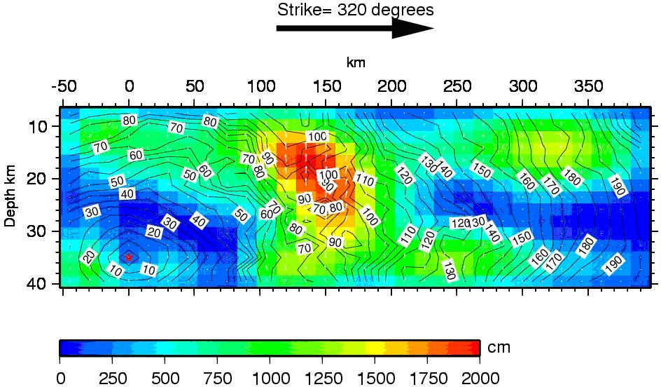
http://neic.usgs.gov/neis/eq_depot/2004/eq_041226/neic_slav_ff.html
Fig. 2. Cross-section of Slip Distribution.
On the above account convergence rates of 14 mm/year, 15-25 mm/year, 40-50 mm/year and 50-60 mm/year have been cited (Lay et al Sci 1128&1132, Stein & Okal Nat 582, Nalbant & Steacy Nat 757, Dalrymple Oceano 143, Satake 30 May). Similarly slip rates of 3-20 m have been reported (Bilham Sci 1127, Lay et al Sci 1130&32, (Ammon &Ji Sci 1136&37& 38, McCloskey Nat 291, Sieh Nat574, Stein & Okal Nat 581). Inversion model analysis of sea surface height recorded by satellite altimetry suggests maximum slip of 25-40 m (Seno & Hirata 15 Feb, Fuji & Satake 30 May). Based on these values of annual convergence rate and average slip during the rupture, recurrence intervals of 400 to 1500 years may be inferred for an earthquake of magnitude greater than 9 in the Sumatra-Andaman fault (Stein & Okal Nat 582, Sieh Nat 574). With regard to recurrent interval of tsunami of magnitude similar to December 2004 affecting Sri Lanka, the above estimate is tenable. The frequency of destructive tsunamis in Indonesia is much greater.
26 December 2004 Rupture and Tsunami
The December 2004 main shock rupture began at 3.3oN, 96.0oE at a depth about 30 km at 00.59 UTC (Universal Time Co-ordinated) (Lay Sci 1128). Real-time studies using seismic body waves in the range of 10 to 50s, and even the post-tsunami studies based on records of 300 to 500s period surface waves yielded moment magnitude Mw=9.0 (Lay Sci 1130, Ni Nat 582). The post-tsunami modelling suggests the rupture propagated northward in the first minute rather slowly, then accelerated to 3 km/s for 4 minutes and there after continued at an average speed of about 2.5 km/s for further 6minutes. This sequence of rupture for a length of 1200-1300 km is the longest tsunamigenic earthquake and likewise generated the most devastating tsunami in the recorded history (Lay Sci 1128, 1131, Ni Nat 582). Inversion of regional long-period seismograms in the period range from 100 to 3000s and regional and teleseimic surface waves in the period range from 80 to 300s has yielded moment magnitude of 6.5x10²² Nm or Mw=9.15 (Ammon & JiSci 1136 and my calcs). Analysis of the Earth’s normal modes with periods from about 600 to 3200s has resulted in the moment magnitude Mw=9.3 (Stein & Okal Nat 581). The normal modes are resonance frequencies of the Earth’s standing waves (Lay MGS, Stein ISEES).
Seabed uplift and subsidence as much as 6 m to 10 m over 100-150 km wide area in some places along the fault rupture have been cited (Dalrymple Ocean 143, Keim Oceanog 44, Titov et al Sci 2045). A leading depression wave propagated eastward and leading elevation wave propagated westward both followed by trains of a few longer waves and then many smaller ones (Dalrymple Oceano 143, Rabinovitch & Thomson Pure & App Geoph). There are vague accounts of tsunami arrival on different coastlines of Sri Lanka. From model analysis Fernando et al suggest on the 26 December 2004 the first destructive wave arrived on the east coast of Sri Lanka sometime around 8.50 am local time without any warning of recession (Fernando et al Calgary). From eye witness accounts Wijetunge suggests the second wave was the largest that arrived about 9.30am local time (Wijetunge Tsunami hazards). The tsunami struck the Indian east coast around 0330 UTC (0900 IST). The amplitude was 2m above the tide at Chennai, Paradip and Colombo (TideGauge Obs IO). The first wave arrived at 08:30 to 08:45 at the east coast, followed by the largest wave at 08:50 to 09:15am. At most area at the east coast, the second wave was the largest. At the south and the west coasts, on the other hand, the first wave arrived at 09:15 to 09:45, and the largest wave arrived at 09:50 to 10:30, that were the second or the third wave (Matsumoto et al AGU). The earthquake occurred at 6.28 am local time in Sri Lanka. The first small tsunami wave arrived at the island’s southern tip at 9.10 am. And 2 large waves followed. Only very few people understood the warning of the recession and were able to save their lives (Liu & Lynett et al Sci 1595 and EERI report). The waves accompanied by withdrawal of sea in the western coast may have had undergone diffraction and refraction around the southern coast and reflection from other shores. The tide gauge station in Colombo (06.93oN, 79.83oE) on the west coast recorded 2.7 m height wave at 3.49 UTC (9.49 am local time) and malfunctioned after the first large wave (Rabinovich & Thomson Pure & App Geo, Liu et al Sci 1595, Giest et al Earth planet Space). A transcript of the Colombo tide gauge hydrograph shows at about 9.53 am (local time) a positive wave of 2.6 m amplitude followed by several diminishing oscillations with a maximum initial wave trough of approximately 0.5m amplitude (Basnayake, Dept of Meteorology). In the east and south east coasts tsunami wave followed a direct route from the source after initial focusing by the source configuration (Titov & Ranovich Sci 2047, Geist & Bilek EPS 22 May). Following from the above sequence and considering a distance of 1200 km from the tsunami source to east coast of Sri Lanka the first wave travelled at a velocity of greater than 650 km/hour. The Japanese post-tsunami survey records indicate two to three waves in the southwest coast between 9.15am and 11.30 am local time (Kawata et al Kyoto Uni). Photographs of debris of demolished houses near Galle in the south west coast show one clock stopped at 9.20am and other at 10.17 am (eeri, Prakash Singh).
TSUNAMIS IN THE INDIAN OCEAN
The only historically well documented tsunami affected Sri Lanka was the tsunami generated by the eruption of Krakatoa volcano in Indonesia on 27 August 1883. There is a tentative list of tsunamis in the Bay of Bengal, some resulting a large number of mortalities. (Murty & Rafiq, Nat Hazards). The other historic event of tsunami in Sri Lanka has been some 2000 years ago cited in the ancient chronicle of Sri Lanka entitled Mahavansa. (Duryog Nivaran Chp 4 SAD, Thywissen & Renaud, UN Uni, Brohier AIWC part III). Considering this ancient account BC and the return period of mega tsunami inferred earlier from convergence rate, 400 years seems to be a safe estimate of the return period of destructive tsunami in Sri Lanka (Stein & Okal Nat 582). Once a millennium is a more lax notion (Sieh Nat 574).
Following the December 2004 Sumatra-Andaman earthquake McCloskey from the evidence of co-seismic stress studies announced concern of possibility of an earthquake of magnitude 7-7.5 on the northern Sumatra fault (McCloskey Nat 291). The prediction was promptly followed by a large earthquake of magnitude 8.7 on 28 March 2005 (Nalbant Nat 757). After the March 2005 earthquake in the Sunda trench, seismologists predicted an earthquake of magnitude 7.0-7.5 south of the March 2005 rupture zone (Nalbant Nat 757). On the 17 July 2006 an earthquake of magnitude 7.7 occurred further south in the Java trench (Ammon & Kanamori AGU 2006).
The March 2005 earthquake of magnitude 8.7 did not generate a major tsunami. There are several factors given for this restraint. Firstly the magnitude 8.7 is at least 3 times smaller than the December 2004 earthquake. Apparently the rupture did not propagate all the way to the seafloor, and occurred in shallow sea than its predecessor. The model analysis suggests neighbouring islands of the epicentre contained the tsunami waves within the source region (Kerr Sci 341, Geist USGS). The December 2004 tsunami was focused to the west towards Sri Lanka than the March 2005 tsunami which was focused further south west. In fact March 2005 earthquake generated a noticeable tsunami in Sri Lanka evident from the tide gauge measurement of 0.5 m in Colombo(Giest & Bilek et al Eart Planet Sp, Rabinovich & Thomson Pure & App Geophy). A maximum wave height of 2.3 m was measured at Kirinda while at Colombo (Mutwal Fishery Boat Harbour) the maximum wave height was 0.5 m (Wijeratne, Daily Mirror, Club LK Forums). The effect of March 2005 earthquake and Tsunami on Sri Lanka is benign and supports the estimated return period of a mega tsunami. Since the December 2004 tsunami, the Indian Ocean interim tsunami warning service has issued tsunami alerts in response to a number of earthquakes of magnitude 6.5 or above. Quakes did not actually pose a tsunami threat to Sri Lanka. These events are also favourable phenomena to minimise the chance of a large tsunamigenic earthquake in the Indian Ocean in the future. Frequent earthquakes in the Sumatra fault in the order of magnitude 8.5 or less would release the stress periodically that otherwise would build up in the long-term to cause a mega earthquake with the potential of generating a destructive tsunami in Sri Lanka.
Tsunami Inundation and Impacts in Sri Lanka
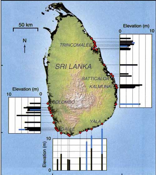
http://www.andaman.org/mapstsunami/SriLankatsunami.jpg
Fig. 3. Tsunami Map of Sri Lanka
The inundation distance inland varies from 50 m to 300 m in most locations except in very few areas especially in the north east where the penetration was as much as 2 to 3 km (Wijetunge Civil Eng Uni of Peradni, Unis of SL, Frerks & Klen Uni of Wagenigan, Sato et al Uni of Tokyo). The team of Liu, Lynett and others has presented the following data of tsunami and runup. Measured tsunami height 4-6m with maximum of 8m in the west coast. Measured runup height 4-10 m with maximum of 13 m in the south coast; and numerical tsunami model height of 1-10 m with maximum of 13 m on west, south and east (Liu et al Sci p 1595, eeri). Wijetunge has presented measured tsunami height recorded by several authors (Wijetunge Tsuna Hazard). The salient figures of these are 2-5 m with maximum of 11m in the west coast, 4-8m with maximum of 11m in the south coast and 3-7m with maximum of 10 m in the east coast. Dias has reported estimated tsunami height varying from 4 to 9m in general and highest 15 m at Batticaloa in the east coast (Dias et al ICE). Correction of destructive tsunami height for tide in the coast of Sri Lanka is usually insignificant (Wijetunge Tsuna Hazard). The spatial distribution of inundation and damage is non-uniform depending on the factors such as coastal topography, bathymetry and population density (Scint of Unis of Sri lanka, Wijetunge Uni of Peradeniya, Wijetunge Tsuna Hazard, Freks & Klen Wagenigan Uni). Except in few regions like south eastern corner where the Yala national park is situated, most of the coastline affected is dotted with small towns and in general highly populated. High density population in a narrow coastal belt was a cataclysmic factor contributed to the death toll and the scale of disaster. One of the cities, Galle in the south west that suffered heavily is a world heritage site.
The salient losses of life and property are: 35000-4000 perished, 200,000 livelihoods lost, 100,000 lost employment, about 500,000 displaced, 2 to 3 million affected, 130, 000 houses destroyed or damaged. Public infrastructure including schools, offices, hospitals, universities, power, roads, railway, harbours, transport, water supply, sanitation, irrigation, fisheries and tourist destroyed or damaged running to an approximate cost of US $ 2 billion. In addition significant environmental damage to farmland, coastal and marine ecosystems including coral reefs, mangroves, sand dunes and beaches (EU 6 Feb, Jayawardane, Dias et al ICE, Freks & Klen Wageningan Uni, Kusakabe et al). Besides 100,000 houses raised to ground a train full of some 1500 people including locals took refuge was consumed by the tsunami in the west coast. The damage to rail track and bridges on the west coast are some awful sights. Though the human catastrophe was unprecented there were no outbreaks of epidemics following the disaster (Keim Oceano 47, WHO 6 Feb). The psychological trauma of losing family members, livelihoods and shelter is a significant impact. More than 70 percent of the dead were fishermen families. The socio-economic impacts of the losses of livelihood and have been expiated to some extent by post-tsunami relief and rehabilitation response with the generosity and efforts of the international community and local organisations (chp 4, EU 6 Feb). The recovery from trauma, and resilience of affected communities is an appreciable quality among the morass of post-tsunami relief and rehabilitation challenge.
Soon after the tsunami struck the island, many local and international teams conducted surveys of coastal inundation, and many other studies of soil transport, scouring, and damage to infrastructure and ecosystems (Fernando et al Calgary, Liu et al eeri, Wijetunge Tsun Hazard, Villholth et al IWMI, Kusakabe et al, Lyttons-ICE, Gibbons et al USGS). Some paleotsunami studies in lagoons have been conducted (Jackson, Eberli et al, Jackson. K.L, Rankey. E. C et al. Jackson, Amelung et al). Paleotsunami research is based on sedimentology and geomorphology, and can enhance the historical records of tsunami events (Scheffers & Kelletat).
The inundation patterns demonstrate all the concepts of tsunami intrusion through rivers, openings in sand dunes, coral reefs, and lagoons Liu, Lynette & Fernando, Sci 1595, Fernando Calgary). Indeed the different tsunami heights even in the same coastal stretch should be a manifestation of variations in the bathymetry. Unlike the post-tsunami inundation survey data, detail bathymetry data are not available for Sri Lanka coastline which is a serious drawback to synthesize a reliable relation between shoaling bathmetry and the runup height. The tsunami wave profile depicted in Fig (3) is adopted from a simulated tsunami wave form at Yala in the south east (Horrillo & Kowalik, Alaska University & Japan Sci of Tsunami Hazard 25 2006, 22 Feb). Numerous reports available on the Internet describe the damage that has been caused to coastal environment, especially the removal of coral and sand, and the development activities that have abetted the impacts of tsunami. It is evident that if the coast conservation Act and the guidelines in the Coastal Zone Management Plan were effectively implemented the damage caused by 2004 tsunami could have been reduced (Jayawardane).
A key outcome of tsunami impacts is that tsunami exacerbated all the existing social, economic, land use, building resources and environmental pressures to far greater level. Contamination of shallow wells was a widespread impact of the tsunami inundation. Salinity in wells in the coastal belt is an endemic problem. Salinity of well water is precariously balanced by the freshwater table depended on the regular rainfall. The study on contamination of shallow wells in the east coast illustrates how the tsunami inundation exacerbated the sensitive salinity of coastal wells to a catastrophic situation by infiltrating the surrounding ground as well as contaminating the freshwater bodies. Outcome of the study is that there is no quick fix solution for the problem other than careful, controlled pumping not only to remove the seawater filled in, but also to remove the other contamination substances such as oil and agricultural chemicals mixed in the tsunami runup (Villholth et al, IWMI 9 Feb; Lucy Lytton-ICE Feb 2008). Beyond that the nature has to take its own cause of biodegradation and stabilisation of salinity levels.
A hypothetical solution to the problem is to recharge the well with imported fresh water and pump out the groundwater from satellite borehole wells around the well to be decontaminated. This is a technically feasible industrial solution which is costly. It is not realistic for rapid rehabilitation of drinking water wells polluted by tsunami.
Disaster Management
Before 26 December 2004 Sri Lanka had no living memory of a tsunami impacts. Having had no experience of tsunami hazard and not aware of an impending tsunami threat, it was not a disaster Sri Lanka could evoke. Sri Lanka suffers from frequent natural disasters mainly from floods, landslides, droughts, coastal erosion and cyclones (Jayawardane, Nat Bld res Org). To mitigate the impacts of these natural disasters Sri Lankan government with the financial assistance from the United Nations Development Programme (UNDP) had in July 1996 established the National Disaster Management Centre (Jayawardane). Since then following the December 2004 Disaster Management Act No.13 of 2005 was ratified on 13 May 2005. This Act provides for a framework for disaster management holistically leading to a policy shift from response based mechanism to a proactive approach toward disaster risk management (SL Parli Select Com). Towards a Safer Sri Lanka: Road Map for Disaster Risk Management is a key government policy document published by the Disaster Management Centre in December 2005 (Jayawardane, Chp 4 SADReport). National tsunami warning system is linked to the national disaster management plan and built into an end-to-end multi-hazards warning system (Report UNESCO 2007).
Numerous government agencies have been established to administrate, promote and implement the government policy objectives in the areas of disaster management, reconstruction and development, whose responsibilities spread across the country on all types of natural disasters that occur frequently. Both medium-term and long-term tsunami hazard warning and mitigation planning are a priority onus of disaster management. This responsibility is shared with multilateral and bilateral international agencies such as various agencies of the United Nations (UN), European Union (EU), United States (US) National Oceanic and Atmospheric Administration (NOAA), and World Bank. Both the Sri Lankan government and the international partners pursue agendas for developing tsunami prepared communities and implementing tsunami hazard warning and mitigation plans in a multilayered, overlapping collaborative programme. Besides financial and technical assistance, it facilitates quality assurance of the tsunami hazard mitigation programme in Sri Lanka (SLParliaSelectComm, EC TIP,IOC UNESCO Capacity Ass 2005,2007, IOTWS UNESCO 2006,2007, IOC Tech Series 71).
As a preliminary planning measure of tsunami hazard mitigation the Sri Lankan government has declared a 100m wide buffer zone in general along the coastline and 200m wide zone along the coastline in the north east where the tsunami penetration was deeper. This measure is controversial, partly because it is not based on inundation maps, and partly it exacerbates the already vexing scarcity of land for housing and cause delay and conflict in rehabilitation process (Chp 4 Tides & Trauma). However as a cursory measure, considering its long-term effect the declared buffer zone deems to be an astute action.
Tsunami warning in Sri Lanka
After the 26 December 2004 tsunami, the interim regional system of the Indian Ocean Tsunami Warning and Mitigation System (IOTWS) is facilitated by partnership of the United Nations Educational Scientific and Cultural Organisation’s Intergovernmental Oceanographic Commission (UNESCO-IOC), NOAA, the Pacific Tsunami Warning and Mitigation System (PTWS) and Japan Meteorological Agency (JMA) (UNESCO-2006, 2007TS71-IOTWS). The Intergovernmental Coordination Group for the Indian Ocean Tsunami warning and Mitigation System (ICG/IOTWS) is serving as the regional body to plan and co-ordinate the design and implementation of an effective and durable tsunami warning and mitigation system (IOTWS-UNESCO 2007TS71). Instrument systems of Deep-ocean Assessment and Reporting of Tsunamis (DART) such as tsunameters or bottom pressure gauges are being installed in the Indian Ocean by India, some other member states of the Indian Ocean and other international partners including NOAA, which will improve the accuracy and effectiveness of tsunami warnings and moderate the issue of tentative tsunami warnings at regional level. The tide gauge in Colombo has been upgraded. The two tide gauges, one at Kirinda in the south east and the other at Trincomalee in the north east which were destroyed by the 2004 tsunami have been reconstructed. (IOC-UNESCO2007 TS 71, capacity assessment UNESCO).
Local tsunami warnings are issued in direct response to tsunami alerts received from the regional warning centres. The interim regional centre is Pacific Tsunami warning Centre (PTWC). The meteorological department in Colombo is the interim tsunami warning centre in Sri Lanka which is manned 24 hours 7 days a week upon the receipt of a possible tsunami warning from the PTWC. Warning messages are transmitted to vulnerable communities by police and military communication systems, local authority officials by email, telephone, fax and helicopter; and by radio and television in general to the public. Local police use mobile public address systems to broadcast warning to the communities. Tsunami inundation maps are being prepared and tsunami ready model villages that perform mock drills have been developed. These will be extended to other coastal towns and villages in due course (Reports Bali UNESCO 2006, Report 25 Capacity assessment UNESCO, Herath-UN Uni, Wijetunge, Wang & Liu, Wijetunge Uni of Pera).
Building and Civil Engineering Infrastructure
Most of the destroyed and damaged buildings are single story and some two or three story concrete framed, masonry buildings (Dias, ICE). There are also houses built of clay and shanty housing. Two prominent failure mechanisms are evident caused by tsunami runup forces. One is toppling or shearing of walls from the foundations. The other is scouring and undermining of foundations especially when the superstructure is resistant to the tsunami force (Dias, ICE). A gutter apron on the perimeter of a building could provide some resistance to foundation scouring. Another inference is that buildings with open ground floor without walls or form and configuration that facilitate a free passage for tsunami runup while retaining structural integrity perform well. Breakaway walls or infill are an integral component of this concept (Yeh, Robertson and Preuss, 30 Jan). Masonry buildings are constructed on empirical practices. The structural concepts of masonry buildings are: cross wall, cellular, core and framed buildings with infill (Hendry, Struct Masonry).
International and local manuals and guidelines are available for design and construction for natural disasters (Dias, ICE, FEMA, Buijs et al DEFRA). However a priority principle in the hierarchy of design for tsunami is, avoid new development in tsunami runup areas. There are some lessons to be pondered in the failure of flood defence infrastructure in the hurricane disaster in New Orleans.
Design and construction of tsunami resistant buildings in general is not realistic. The guidelines available are for the assessment of tsunami forces on structures that can be used in conjunction with respective codes of practice for structural design. Tsunami resistant structures should withstand both the forces due to seismic ground accelerations and the ensuing tsunami runup forces (Yeh et al). Sri Lanka is not a seismic zone, though mild seismicity of magnitude less than 3 is monitored in the central hill region ( ). The December 2004 Sumatra-Andaman earthquake resulted in an impact of II-III intensity in Mercali Scale (SL Parli Select Comm 6Feb). Houses built in a high risk inundation area do not satisfy the serviceability requirements. Even the robust reinforced concrete buildings subject to tsunami waves of 2-10 m or more do not satisfy the serviceability or safety in the ground floor and lower floors. Special structures like tsunami evacuation structures can be designed for both functionality and ultimate limit state criteria.
As evident from the post-tsunami surveys, roads and rail tracks are liable for severe erosion, scouring and uplift. Bridges and causeways can suffer various type of damage to piers, abutments, decks and approach embankments. Water supply, sanitation and irrigation infrastructure may suffer various degree of damage depending on the circumstances of the respective cases. Buildings and structures should only be built in tsunami vulnerable areas on the basis of a risk assessment and cost-benefit analysis, and following the guidelines for planning and design for tsunami hazard such as US National Tsunami Hazard Mitigation programme (NTHMP) (Eisner, DTR). A hazard is a condition or situation of danger posing a risk. Risk is a concept made of the product of two components. One is the probability and the other is corresponding magnitude or severity. These two factors can be given relative values from 0 to 1. If probability is 0.4 and the corresponding severity is 0.6 the relative risk in a scale of 0 to 1 is 0.4 0.6= 0.24. In spite of whole of Pacific Ocean is a frequent tsunami prone region, only Japan has resorted to ultimate structural measures to defend fishing villages from tsunami hazard (Fukuchi & Mistsuhashi, Tsunamis). Development into parks resort and open spaces is a recommended planning measure for tsunami hazard prone areas (Pruess, tsunamis).
Tsunami Preparedness
Important features of tsunami preparedness can be summarised as follows.
- Public education of tsunami awareness and preparedness. To this end tsunami hazard, mitigation and preparedness are included in the school and university curricula.
- Preparation of inundation maps, evacuation routes, safe sites and buildings.
- improving the reliability of tsunami warning dissemination – both the probability of tsunami reaching Sri Lanka and the effectiveness of dissemination to vulnerable communities.
- Training operational staff for real-time tsunami monitoring and for tsunami research.
- Planning medium and long-term housing and public infrastructure identifying the hierarchy of minimising risks, hazards and vulnerability.
The principles of designing for tsunami proposed by US NTHMP (Eisner,DTRC).
- Know your community’s tsunami risk, hazard, vulnerability and exposure.
- Avoid new development in tsunami runup areas to minimise future tsunami losses.
- Locate and configure new development that occurs in tsunami runup areas to minimize future tsunami losses through redevelopment, retrofit, land reuse plans and projects.
- Take special precautions in locating and designing infrastructure and critical facilities to minimize tsunami damage.
- Plan for evacuation.
A lesson from the December 2004 tsunami is that it is the highest inundation area reasonably conceivable for community tsunami hazard mitigation. Albeit the above, tsunami hazard warning is planned by modelling different scenarios. In the same token inundation maps are far reaching and extend farther inland than the boundaries surveyed of the December 2004 tsunami inundation. Considering the adverse impacts of 100 m buffer zone the inundation maps are cumbersome for community development and are suitable for long-term planning of major infrastructures and tsunami evacuation planning. The surveyed boundaries of December 2004 tsunami inundation should be demarcated for posterity as a defence line for community land use. Evacuation routes should be sign posted. The goal of tsunami hazard mitigation for Sri Lanka is to build a culture of long-term planning of infrastructure for tsunami risk mitigation, developing local warning and evacuation infrastructures. The strategy for Sri Lanka is to develop a culture of tsunami aware and tsunami prepared community both in the context of infrastructure and evacuation with primary objective being to hand down to the future generations.
Concluding Remarks
The December 2004 earthquake monitoring was the most devastating tsunami earthquake with the longest rupture period. Real-time earthquake monitoring measured the earthquake magnitude as 9. Subsequent seismic studies using very long period waves determined the magnitude as 9.3. Prior to 26 December 2004 tsunami Sri Lanka had no living memory of tsunami hazard and without international prior warning, Sri Lanka was not prepared for such a disaster. The tsunami inflicted an unprecedented scale of human disaster, extensive infrastructure and environmental damage. The government and nongovernmental response, international support for tsunami relief and rehabilitation, and scientific studies were prompt. The immediate turmoil and hardships were palpable but there were no outbreaks of epidemics.
Tsunami inundation and runup though was non-uniform in general about 100m and average runup height was about 5-9 m. Maximum runup height in south coast at Yala is 13m where a tourist hotel was obliterated. Sri Lanka government has declared a 100m buffer zone along the coastline in general and 200 m in the north east where penetration was greater than 1km. Although this measure is controversial and impeding the tsunami relief and rehabilitation efforts it is deemed rational. The tsunami exacerbated the existing problems of housing, land use, building resources, poverty, salinity of drinking water wells, sea erosion and human inflicted damage to coastal environment. The government disaster management institutions and strategies have been strengthened by comprehensive review and disaster management legislation to respond proactively. Inundation maps and evacuation plans are being prepared and tsunami hazard education is incorporated into the school and university curricula. Tsunami prepared model villages have been developed and these will be replicated. Avoiding new development in tsunami inundation areas is a key recommended principle of tsunami hazard mitigation strategy. The inundation boundaries of December 2004 tsunami should be demarcated for posterity as a frontline defence plan for community development. Tsunami evacuation routes should be sign-posted.
The Indian Ocean Interim Tsunami Warning System is provided by an international consortium including the member states around Indian Ocean, NOAA and JMA under the auspices of UNESCO. Upon the receipt of a regional tsunami warning in Colombo in Sri Lanka the warning is broadcast to vulnerable communities through all available media including telephone, email, radio and TV, and communication channels of police, military, district authorities, local officials and trained volunteers.
Earthquakes of magnitude 6.5-8.5 occur frequently in the Sumatra-Andaman subduction zone. These are not a source of potential damaging tsunami hazard to Sri Lanka. A shallow earthquake of magnitude 9 or more is a potential source for a destructive tsunami hazard in Sri Lanka. From convergence rate and earthquake slip data it is estimated that minimum return period of such a tsunami is about 400 years. Fault line strain-stress monitoring by remote sensing provide a more reliable means of medium-term earthquake prediction in the Sumatra fault. Tsunami threat for Sri Lanka is long-term. The frequent tsunami alerts issued in the region should serve to strengthen and monitor the tsunami preparedness of communities. The long-term onus of tsunami hazard mitigation planning in Sri Lanka is to establish a culture of tsunami hazard mitigation development ethics, tsunami prepared communities, and a legacy of appropriate technological and academic base for the future generations.
Acknowledgements
The author wishes to acknowledge initial discussions with Professors Nick Kusznir and Andreas Rietbrock of the University of Liverpool, online paper by Joe Fernando and others of University of Calgary, illustrations and maps and other online sources of papers and information used and cited in this paper.
References
Crawford.P.L., Tsunami Predictions for the Coast of Alaska Kodiak Island to Ketchikan. Department of the Army Corps of Engineers. Prepared for Federal Emergency Management Agency April 1987. Washington DC.
Okal.E.A., Predicting Large Tsunamis. Nature Vol 361 25 February 1993. p686-687.
Bolt.B.A. Earthquakes. W H Freeman & Co. 1998. ?
Weber G. Chapter 1 of "Earthquake and Tsunami": Maps, Charts and Statistics. The Cause: moving geological plates
www.andaman.org/mapstsunami/1cause/1cause.htm
Lay. T., Kanamori.H., and Ammon.C.J. et al. The Great Sumatra-Andaman Earthquake of 26 December 2004. Science Vol 308 20 May 2005 p1127-1133.
Bilham.R., A Flying start, then a Slow Slip. Science, Vol 308, 20 May 2005. p 1126-1127.
Continental Drift and Plates Tectonics. Ellie Crystal’s Metaphysical and Science Website.
www.crystalinks.com/tectonicplates.html
Windley.B.F. The evolving Continents. John Wiley & Sons. 1995 Chichester.
Li.V.C. and Kisslinger.C. Stress transfer and nonlinear stress accumulation at subduction-type plate boundaries - Application to the Aleutians. Shimazaki.K. and Stuart.W. Editors. Earthquake Prediction. Birkhurst, 1985. Reprinted from Pure and Applied Geophysics. Vol. 122, No. 6, 1984/85.
McCloskey.J., Nalbant.S.S, and Steacy.S. Earthquake Risk from Co-seismic Stress. Nature, Vol. 434, 17 March 2005, p 291.
Hopkin.M. Indonesia Spared tsunami as Disaster Quake Strikes. Nature, Vol. 434, 31 March 2005. p 547
Nalbant.S.S., Steacy.S., et al. Earthquake Risk on the Sunda Trench. Nature, Vol. 435, June 2005, p 756-757.
USGS. Tsunamis and Earthquakes. http://walrus.wr.usgs.gov/tsunami/basics.html
Dalrymple, R.A., Grilli, S.T., and Kirby,J.T. Tsunamis and Challenges for Accurate Modelling. Oceanography. Vol. 19, No. 1 Mar 2006. pp 142-151.
Yoshiaki Kawata et al, Kyoto University. Comprehensive analysis of the damage and its impact on coastal zones by the 2004 Indian Ocean tsunami disaster.www.tsunami.civil.tohoku.ac.jp/sumatra2004/report.html 28 Jan 07
Rabinovich, A.B. and Thomson, R.E. The 26 December 2004 Sumatra Tsunami: Analysis of Tide Gauge Data from the World Ocean Part 1. Indian Ocean and South Africa. Pure and Applied Geophysics. 164 (2007) 261-308, Birkhauser Verlag, Basel. www.pac.dfo-mpo.gc.ca/sci/osap/publ/online/PAG2007_Rabinovich_Thomson261.pdf
Commer.P. Tsunami Eartquakes and Undersea Deformation p 77-92. Tsunamis: Their Science and Engineering. Edited by Iida.K. and Iwasaki.T. Proceedings of the International Tsunami Symposium 1981, pp 77-89. IUGG Tsunami Commission, May 1981, Japan. Terra Scientific Publishing Company (TERRAPUB) Tokyo, REIDEL 1983 London.
Ohmachi.T. et al. Simulation of Tsunami Induced by Dynamic Displacement of Seabed due to Seismic Faulting. Bulletin of the Seismological Society of America. Vol 91, No. 6 December 2001 pp 1898-1909
Okal.E.A. Seismic Parameters Controlling Far-field Tsunami Amplitudes. Natural Hazards. Vol. 1, No. 1, March 1988. p67-96
Okal.E.A. Predicting Large Tsunamis. Nature, Vol. 361, 25 February 1993. p 686-687.
Seno.T. and Hirata.K. Did the 2004 Sumatra-Andaman Earthquake Involve a Component of Tsunami Earthquakes. Bulletin of Seismological Society of America. Vol. 97, No. 1A January 2007 p 8296-8306 15 Feb
Synolakis.C. Liu.P. et al. Tsunamigenic Sea-Floor Deformations. Science, Vol. 278, 24 October 1997. p 598-600
Kanamori.H. and Kikuchi.M. The 1992 Nicaragua Earthquake: A Slow Tsunami Earthquake Associated with Subducted Sediments. Nature, Vol. 361, 25 February 1993. P 714-716
Ruff.L.J. Do trench sediments affect great earthquake occurrence in subduction zones? Journal of Pure and Applied Geophysics. Vol. 129, No. 1-2, March 1989, P 263-282 Birkhuser Basel.
Kanamori.H. and Given.J.W. Use of Long period Seismic Waves for Rapid Evaluation of Tsunami Potential of Large Earthquakes. P Tsunamis: their Science and Engineering. Edited by Iida.K. and Iwasaki. pp 37-49. T. REIDEL 1983 London.
Choi.D.R. Plate Tectonics Subducted Journal of Scientific Exploration, vol. 19, no. 3, pp. 490-495, Fall 2005 http://ourworld.compuserve.com/homepages/dp5/subduct.htm
Stein.S. and Wysession.M. An Introduction to Seismology, Earthquakes, and Earth structure. 2003, Blackwell
Lay.T. and Wallace.T.C. Modern Global seismology. Academic Press 1995 San Diego.
Kanamori.H. Quantification of Earthquakes. Nature Vol 271 2 February 1978 pp 411-414
Richter.C.F. Elementary Seismology. W H Freeman, 1958, San Francisco.
Horikawa.K and Shuto.N. Tsunami Disasters and Protection Measures in Japan. Tsunamis: Their Science and Engineering. Edited by Iida.K. and Iwasaki.T. Proceedings of the International Tsunami Symposium 1981, pp 9-22. Japan. pp 9-22. London.
Gray. C. A Review of Two Methods of Predicting Earthquakes. UER programme. University of Wisconsin. http://tc.engr.wisc.edu/UER/uer96/author3/index.html
Shimazaki.K. and Stuart.W. Editors. Earthquake Prediction. Birkhurst, 1985. Reprinted from Pure and Applied Geophysics. Vol. 122, No. 6, 1984/85.
Bernard.E.N.B. Editor. Developing Tsunami Resilient Communities. The US National Tsunami Hazard Mitigation Program. Reprinted from Natural Hazards. Vol 35(1), 2005 Springer, Netherlands.
Baba, T., Hirata,K., Kaneda, Y. Far-field tsunami magnitude determined from ocean-bottom pressure gauge data around Japan. American Geophysical Union, Fall Meeting 2003 http://adsabs.harvard.edu/abs/2003AGUFMOS22B1156B
Mikada, H. Hirata, K. et al. Scientific Results From Underwater Earthquake Monitoring Using Cabled Observations. Scientific Use of Submarine Cables and Related Technologies, 2003. The 3rd International Workshop on: 25-27 June 2003 pp 3- 7 http://ieeexplore.ieee.org/xpl/freeabs_all.jsp?tp=&arnumber=1224100&isnumber=27473
Kato, T. Terada, Y. et al. A New Tsunami Monitoring System Using RTK-GPS. ITS 2001 Proceedings, session 5, No. 5-12 pp645-651.
http://nthmp-history.pmel.noaa.gov/its2001/Separate_Papers/5-12_Kato_T.pdf
Pararas-Carayannis,G. The Tsunami Impact on Society. Tsunamis: Their Science and Engineering. Edited by Iida.K. and Iwasaki.T. Proceedings of the International Tsunami Symposium 1981, pp 3-8. Japan. REIDEL 1983 London.
Sorensen,R.M. Basic Coastal Engineering. John Wiley 1978
Keim.M.E, Cyclones, tsunamis, and Human Health. The key role of preparedness. Oceanography. Vol. 19, No. 2, June 2006. pp 40-49.
Yeh,H. Liu,P. et al. Propagation and Amplification of Tsunamis at Coastal Boundaries. Nature. Vol. 372, 24 November 1994. pp 353-355.
Titov, V. Rabinovich,A.B et al. The Global Reach of the 26 December 2004 Sumatra Tsunami. Science Vol. 309, 23 September 2005. pp 2045-2048.
Joe Fernando, J. Braun, A. et al The Indian Ocean Tsunami of December 26, 2004:
A Journey through the Disaster with an Emphasis on Sri Lanka.
www.eng.ucalgary.ca/resrch_civil/publications/IndianOceanTsunami.doc
Liu, P.L. Lynett, P. Fernando, H. et al. Observations by the International Tsunami Survey Team in Sri Lanka. Science. Vol. 308, 10 June 2005. p1595.
UNESCO. Post-tsunami survey Field Guide. International Oceanographic Commission, Manual and Guides 37, 1998.
Smith, W.H.F. Scharroo, R. et al. Satellite Altimeters Measure Tsunami. Oceanography. Vol. 18, No. 2, June 2005.
http://www.eri.u-tokyo.ac.jp/topics/SUMATRA2004/abe.html
Abe, K., J.Seismol. Soc. Japan, 52, 369-377, 1999
http://www.eri.u-tokyo.ac.jp/topics/SUMATRA2004/abe.html
About.com:Geology. Tsunami Intensity Scale http://geology.about.com/library/bl/bltsunamiscalenew.htm
Ammon, C.J. Ji, C. Thio, H. et al. Rupture Process of the 2004 Sumatra-Andaman Earthquake. Science. Vol. 308, 20 May 2005, pp1133-1139.
McCormick,
Satake. K. The 2004 Sumatra-Andaman Earthquake and Tsunami in the Indian Ocean.
www.cea-igp.ac.cn/English.files/pdf/The%202004%20Sumatra-Andaman%20Earthquake%20and%20Tsunami%20in%20the%20Indian%20Ocean.pdf
Synolakis, C.E. Tsunami Runup on Steep Slopes: How Good Linear Theory Really Is. Natural Hazards, 4(2/3), pp221-234.
Heller, V., Unger, J., and Hager, W. Tsunami Run-up – A Hydraulic Perspective. Journal of Hydraulic Engineering ASCE. Vol. 131 No. 9, September 2005. pp 743-747.
Yeh, H.H. Tsunami Bore Runup. Natural Hazards, 4(2,3, pp209-220, 1991.
Camfield, F.E., and Street, R.L., Shoaling of Solitary Waves on Small Slopes. Journal of the Waterways and Harbours Division. Vol. 95, No. WW1, February 1969, Proceedings of the American Society of Civil Engineers.
Li., Y. and Raiclen, F. Solitary Wave Runup on Plane Slopes. Journal of waterway, port, Coastal and Ocean Engineering, Vol. 127, No. 1, January/February 2001. ASCE.
Titov, V.V. and Synolakis, C.E. Modelling of Breaking and Nonbreaking Long-Wave Evolution and Runup Using VTCS-2. Journal of waterway, port, Coastal, and Ocean Engineering, Vol. 121, No. 6, November/December 1995. ASCE.
Kirkgoz, M.S., Breaking and Run-up of Long waves. Tsunamis: Their Science and Engineering. Edited by Iida.K. And Iwasaki.T. Proceedings of the International Tsunami Symposium 1981, pp 467-478. Japan. REIDEL 1983 London.
Bagnold, R.A., sand Movement by waves : Some Small-Scale Experiments with Sand of Very Low Density. Journal of the Institution of Civil Engineers. Vol. 27, No. 4, Paper No. 5554, 1946-47, Feb 1947, pp 447-469.
Liu, P. Effects of the Continental Shelf on Harbour Resonance. Tsunamis: Their Science and Engineering. Edited by Iida.K. And Iwasaki.T. Proceedings of the International Tsunami Symposium 1981, pp 303-314. Japan. REIDEL 1983 London.
Horrillo, J, Kowalik, Z. et al. Wave Dispersion study in the Indian Ocean Tsunami by et al University of Alaska, Fairbanks. Science of Tsunami Hazards. Vol. 25, No. 1, 2006. p62. http://www.sthjournal.org/251/horrillo.pdf
Part II
Bilham.R., A Flying start, then a Slow Slip. Science, Vol 308, 20 May 2005. p 1126-1127.
Lay. T., Kanamori.H., and Ammon.C.J. et al. The Great Sumatra-Andaman Earthquake of 26 December 2004. Science Vol 308 20 May 2005 p1127-1133.
Dias.P., Dissanayake, R. and Chandratilake, R. Lessons Learned from Tsunami Damage in Sri Lanka. Civil engineering 159, May 2006, Paper 14199, pp 74-81. Proceedings of ICE.
Satake. K. The 2004 Sumatra-Andaman Earthquake and Tsunami in the Indian Ocean.
www.cea-igp.ac.cn/English.files/pdf/The%202004%20Sumatra-Andaman%20Earthquake%20and%20Tsunami%20in%20the%20Indian%20Ocean.pdf
Liu, P.L. Lynett, P. Fernando, H. et al. Observations by the International Tsunami Survey Team in Sri Lanka. Science. Vol. 308, 10 June 2005. p1595.
Liu.P.L.F. Lynett. P. et al. The Great Sumatra earthquake and Indian Ocean Tsunami of December 26, 2004.EERI Special earthquake Report – June 2005. Earthquake Engineering Research Institute. http://www.eeri.org/lfe/pdf/sri_lanka_tsunami_eeri_survey.pdf
Weber G.
http://www.andaman.org/mapstsunami/1cause/1cause.htm
Romanowicz, B. and Giardini, D. The Future of Permanent Seismic Networks. Science. Vol. 293, 14 September 2001, pp 2000-2001.
Stein.S. and Wysession.M. An Introduction to Seismology, Earthquakes, and Earth structure. 2003, Blackwell
Crawford.P.L., Tsunami Predictions for the Coast of
Ji, C., Caltech, Preliminary Rupture Model. USGS Earthquake Centre.
http://neic.usgs.gov/neis/eq_depot/2004/eq_041226/neic_slav_ff.html
Stein, S. and Okal, E.A. Speed and Size of the Sumatra Earthquake. Nature, Vol. 434, Issue 7033, March 2005, pp 581-582.
Nalbant.S.S., Steacy.S., et al. Earthquake Risk on the Sunda Trench. Nature, Vol. 435, June 2005, p 756-757.
Dalrymple, R.A., Grilli, S.T., and Kirby,J.T. Tsunamis and Challenges for Accurate Modelling. Oceanography. Vol. 19, No. 1 Mar 2006. pp 142-151.
Bilham.R., A Flying start, then a Slow Slip. Science, Vol 308, 20 May 2005. p 1126-1127.
Ammon, C.J. Ji, C. Thio, H. et al. Rupture Process of the 2004 Sumatra-Andaman Earthquake. Science. Vol. 308, 20 May 2005, pp1133-1139.
McCloskey.J., Nalbant.S.S, and Steacy.S. Earthquake Risk from Co-seismic Stress. Nature, Vol. 434, 17 March 2005, p 291.
Sieh, K. What Happened and What’s Next? Nature. Vol. 434, 31 March 2005, pp 573-574.
Seno.T. and Hirata.K. Did the 2004 Sumatra-Andaman Earthquake Involve a Component of Tsunami Earthquakes. Bulletin of Seismological Society of America. Vol. 97, No. 1A January 2007 p 8296-8306 15 Feb
Fujii, Y. and Satake, K. Tsunami Source of the 2004 Sumatra–Andaman Earthquake Inferred from Tide Gauge and Satellite Data. Bulletin of the Seismological Society of America; January 2007; v. 97; no. 1A; p. S192-S207
Ni, S. Kanamori, H. and Helmberger, D. Energy radiation from the Sumatra Earthquake. Nature. Vol. 434, 31 March 2005, p 582
Stein.S. and Wysession.M. An Introduction to Seismology, Earthquakes, and Earth structure. 2003, Blackwell
Lay.T. and Wallace.T.C. Modern Global seismology. Academic Press 1995 San Diego.
Keim.M.E, Cyclones, tsunamis, and Human Health. The key role of preparedness. Oceanography. Vol. 19, No. 2, June 2006. pp 40-49.
Titov, V. Rabinovich,A.B et al. The Global Reach of the 26 December 2004 Sumatra Tsunami. Science Vol. 309, 23 September 2005. pp 2045-2048.
Rabinovich, A.B. and Thomson, R.E. The 26 December 2004 Sumatra Tsunami: Analysis of Tide Gauge Data from the World Ocean Part 1. Indian Ocean and South Africa. Pure and Applied Geophysics. 164 (2007) 261-308, Birkhauser Verlag, Basel.
www.pac.dfo-mpo.gc.ca/sci/osap/publ/online/PAG2007_Rabinovich_Thomson261.pdf
Joe Fernando, J. Braun, A. et al The Indian Ocean Tsunami of December 26, 2004:
A Journey through the Disaster with an Emphasis on Sri Lanka. www.eng.ucalgary.ca/resrch_civil/Civil_Wirasinghe.htm
www.eng.ucalgary.ca/resrch_civil/publications/IndianOceanTsunami.doc
Wijetunge. J.J. Tsunami on 26 December 2004: Spatial Distribution of Tsunami height and the Extent of inundation I Sri Lanka. Science of tsunami hazards, Vol. 24. No. 3. 2006. pp 225-239 http://www.sthjournal.org/243/wijet.pdf
Nagarajan et al., Tide-gauge observations of the 2004 Indian Ocean tsunami. Earth Planets Space, 58, 211-215, 2006.
http://www.nio.org/jsp/tide_gauge.htm
Matsumoto, H.; Inoue, S.; Wijeyewickrema, A. et al. Tsunami Arrival Time in Sri Lanka for the 2004 Sumatra-Andaman Earthquake. American Geophysical Union, Fall Meeting 2005, abstract #U11A-0820. December 2005.
http://adsabs.harvard.edu/abs/2005AGUFM.U11A0820M
Geist, E. L. Bilek, S.L. et al. Differences in Tsunami Generation between the December 26, 2004 and March 28, 2005 Sumatra Earthquakes. Earth Planets Space, 58, 185-193, 2006.
http://walrus.wr.usgs.gov/reports/reprints/Geist_EPS_58.pdf
Basnayake. S. Assessing Adaptation Responses to Climate Changes in Coastal Zones of Sri Lanka. Centre for Climate Changes Studies, Department of Meteorology. Sri Lanka. UNFCCC Asian regional Workshop on Adaptation, 11-13 April 2007. Beijing.
http://unfccc.int/files/adaptation/adverse_effects_and_response_measures_art_48/application/pdf/basnayake_coasts.pdf
Kawata, Y. Imamura, F. et al. Kyoto University. The December 26, 2004 Sumatra Earthquake Tsunami, Tsunami Field Survey around Galle, Sri Lanka
http://www.drs.dpri.kyoto-u.ac.jp/sumatra/srilanka/galle_survey_e.html
Prakash Singh/AFP/Getty Images. www.unep.org/tsunami/reports/TSUNAMI_SRILANKA_LAYOUT.pdf
Murty. T.S. and Rafiq. M. A Tentative List of Tsunamis in the Marginal Seas of the North Indian Ocean. Natural hazards 4 (1) pp 81-83, 1991.
Duryog Nivaran. South Asia Disaster Report 2005. Tackling the Tides and Tremors. Chapter 4. Tsunami in Sri Lanka: Damages and Deliveries. http://duryognivaran.org/sadr/index.html
http://duryognivaran.org/sadr/pdfs/chapter4.pdf
Thywissen. K. and Renaud. F. Devastation and Reconstruction: The Situation in Sri Lanka After the 2004 Tsunami. Observations from 3 UNU-EHS missions to Sri Lanka in February 2005, July 2005 and January 2006. http://www.ehs.unu.edu/article:209?menu=73
Herath.S. Post Tsunami Survey for Hazard map Preparation in Sri Lanka. S.Herath, United Nations University, Tokyo.
http://ares.tu.chiba-u.jp/workshop/Chiba-RS2005/Paper%20Hearth.pdf
R.V.Brohier (1935), Ancient Irrigation Works in Ceylon, Part III, p.1-2,
Ammon.C.J, Kanamori.H. et al. The 17 July 2006 Java Tsunami Earthquake (Mw = 7.8) Eos Trans. AGU, 87(52), Fall Meeting 2006.
Kerr.R.A. Model Shows Islands Muted Tsunami After Latest Indonesian Quake. Science. Vol. 308, 15April 2005 p 341.
Geist. E.L Why wasn’t There a Larger Tsunami from the Magnitude 8.7 March 28, 2005, Sumatra Earthquake? USGS. http://soundwaves.usgs.gov/2005/04/SW200504-144.pdf
Wijeratne. E.M.S. Tsunami waves did arrive this time too: NARA Daily Mirror Friday 08 April 2005. http://www.dailymirror.lk/2005/04/08/news/7.asp
Wijeratne. E.M.S. CLUBLK Forum. Tsunami waves recorded at Kirinda and Colombo on March 28: NARA http://www.clublk.us/ftopic-3131-165.html
Universities of Sri Lanka. Synopsis of Post-Tsunami Rapid Environmental Assessments in Sri Lanka.
Wijetunge.J.J. Civil engineering Department Surveys: The Extent of Tsunami Inundation. Peradeniya Engineering Faculty Alumni Association (PEFAA) Newsletter. Vol. 15, No.1 April 2004. Department of Civil Engineering, University of Peradeniya.
http://www.pdn.ac.lk/eng/pefaa/newsletter/vol15/1501/PAGES2-3.pdf
Freks. G. and Klen. B. Tsunami Response in Sri Lanka. Wageningen University. Netherland. 14 March 2005.
www.clingendael.nl/publications/2005/20050300_cru_other_frerks.pdf
Sato. S., Koibuchi. Y., et al. 2004 Dec 26 Tsunami - Sumatra Earthquake, Field Investigations carried out in Sri Lanka. University of Tokyo.
http://www.drs.dpri.kyoto-u.ac.jp/sumatra/srilanka-ut/SriLanka_UTeng.html
Jayawardane.A.K.W. Disaster Mitigation Initiatives in Sri Lanka. Univeristy of Moratuwa, Sri Lanka. http://management.kochi-tech.ac.jp/PDF/IWPM/IWPM_Jayawardane.pdf.
Kusakabe. T. Matsuo. O. and Kataoka. S. Introduction of a Methodology to Mitigate Tsunami Disaster by Pre-evaluation of Tsunami damage Considering damage investigation of 2004 Tsunami disaster in the Indian Ocean.
www.pwri.go.jp/eng/ujnr/tc/g/pdf/21/21-3-3kusakabe.pdf
World Health Organisation. Tsunami and Health. Situation report#33, 4 February 2005.
http://www.wpro.who.int/NR/rdonlyres/3B45323E-A139-45B9-BE63-FC9ECAF0665C/0/SitRep33_3Feb05.pdf
European Commission. Tsunami Indicative Programme, Indonesia, Sri Lanka, Maldives(2005-2006) 23 May 2005. http://ec.europa.eu/world/tsunami/docs/tip_05-06_c1490.pdf
Villholth. K.G. and Amerasinghe. P.H. et al. Tsunami Impacts on Shallow Groundwater and Associated Water Supply on the East Coast of Sri Lanka. IWMI International Water management Institute. http://www.iwmi.cgiar.org/TSUNAMI/Index.asp
http://www.iwmi.cgiar.org/TSUNAMI/pdf/Tsunami_Impacts_on_Shallow_Groundwater.pdf
Lytton L. Deep Impact: Why Post-Tsunami Wells need a Measured Approach. Civil engineering. February 2008, Vol. 161, pp 42-48. Proceedings of the Institution of Civil Engineers.
Gibbons. H., Oates. J.L. and Jaffe. B. USGS Scientists Study sediment Deposited by 2004 Indian Ocean Tsunami.
http://soundwaves.usgs.gov/2005/02/SW200502-225.pdf
Jackson. K.L. Eberli. G. et al. The Tsunami History of the Indian Ocean Inferred from Coastal Lagoon Sediments in Sri Lanka. http://mgg.rsmas.miami.edu:8080/CSL/Medialib/view_file?
Jackson. K.L, Rankey. E.C. et al. Are Tsunamis Always Sedimentologically Important Events? A case Study of Sedimentological and Geochemical Analyses of Coastal Regions, Sri Lanka. http://aapg.confex.com/aapg/2007am/techprogram/A111403.htm
Jackson. K.L, Amelung. F. et al. Tsunami Sediments in Coastal Lagoons, Sri Lanka: Implications for Paleotsunamis. http://www.searchanddiscovery.com/documents/2006/06088houston_abs/abstracts/jackson02.htm
Scheffers. A. and Kelletat.D. Sedimentologic and Geomorphologic Tsunami Imprints Worldwide-a Review. Earth science Reviews. Vol. 63, Nos 1-2, October 2003, Elsevier.
Horrillo. J. and Kowalik. Z. Shigihara. Y. Wave Dispersion Study in the Indian Ocean, Tsunami of December 26, 2004. Science of Tsunami Hazards, Vol. 25, No.1, 2006. pp 42-63.
www.sthjournal.org/251/horrillo.pdf
The Sri Lankan Parliament Select Committee to recommend Steps to minimize the Damages from Natural Disasters. http://www.srilankanparliamentonnaturaldisasters.org
www.srilankanparliamentonnaturaldisasters.org/Key%20Recommendations.htm
www.srilankanparliamentonnaturaldisasters.org/Final%20Report.doc
Intergovernmental Oceanographic Commission. Expert Missions to Indian Ocean Countries to Assess Requirements and Capacity for an Effective and Durable National Tsunami Warning and Mitigation System. Sri Lanka, Colombo. 19-21 May 2005. Mission report No. 25. UNESCO 2005.
http://ioc3.unesco.org/indotsunami/documents/nationalreports/IOC25_Assessment_Sri%20Lanka.pdf
Indian Ocean Consortium. Strengthening National Capacities for Tsunami early warning and Response Systems in Indian Ocean. ICG/IOTWS meetings, Bali, 1 August 2006. 1 March 2007, Mombasa, Kenya.
Intergovernmental Oceanographic Commission. Reports of Governing and Major Subsidiary Bodies. Intergovernmental Coordination Group for the Indian Ocean Tsunami Warning and Mitigation System (ICG/IOTWS) Third Session, Bali, Indonesia. 31 July-2 August 2006. UNESCO 2006. http://unesdoc.unesco.org/images/0015/001509/150937e.pdf
Intergovernmental Oceanographic Commission. Reports of Governing and Major Subsidiary Bodies. Intergovernmental Coordination Group for the Indian Ocean Tsunami Warning and Mitigation System (ICG/IOTWS) Fourth Session, Mombasa, Kenya. 28 February-2 March 2007. UNESCO 2007. http://ioc3.unesco.org/icg/files/ICG-IOTWS_IV.pdf
Intergovernmental Oceanographic Commission. Technical series 71. Indian Ocean Tsunami Warning and Mitigation System (IOTWS). Implementation Plan. Fourth Session of the Intergovernmental Coordination Group for the Indian Ocean Tsunami Warning and Mitigation System (ICG/IOTWS-IV) Mombasa, Kenya. UNESCO 2007. 28 Feb-2 Marchhttp://ioc3.unesco.org/indotsunami/documents/IOC%20Technical%20Series%2071%20Report_March07.pdf
www.ioc-tsunami.org/
http://ioc3.unesco.org/indotsunami/
Hagemeyer. R.H. NOAA, Pacific tsunami warning centre and Japan Meteorological Agency.
Communication Plan for the Interim Tsunami Advisory Information Service for the Indian Ocean region. 15 January 2006. UNESCO
http://ioc3.unesco.org/indotsunami/documents/IOTWS_CommunicationPlan_15Jan06.pdf
J.J.Wijetunge.J.J, Wang.X. and Liu. P.L.F et al. Preliminary Tsunami Hazard Map of the City of Galle, Sri lanka. 2007. www.civil.pdn.ac.lk/tsunami/hazard_map_galle.pdf
Wijetunge.J. Near and Onshore Tsunami effects: Ongoing and Planned Research in Sri Lanka. University of Peradeniya, Sri Lanka.
Yeh. H., Robertson. I, and Preuss. J., Development of Design Guidelines for Structures that Serve as Tsunami Vertical Evacuation Sites.
Hendry. A.W., Structural Masonry, MacMillan, 1998.
Federal Emergency Management Agency. Coastal Construction Manual-Principles and Practices of planning, Siting, Designing, Constructing and Maintaining Residential Buildings in Coastal areas. FEMA 55, Washington
Buijs. F., Simm. J., et al. Performance and Reliability of Flood and Coastal Defences. R&D Technical report FD2318/TR2, Environment Agency. Department for Environment, Food and rural Affairs (DEFRA), Flood Management Division. August 2007.
Seismicity monitoring in Sri Lanka. University of Utra Pradesh
Bernard. E.N.B. Editor. Developing Tsunami Resilient Communities. The US National Tsunami Hazard Mitigation Program. Reprinted from Natural Hazards. Vol 35(1), 2005 Springer, Netherlands.
Fukuchi. T. and Mitsuhashi. K. Tsunami Countermeasures on Fishing Villages Along the Sanriku Coast. Tsunamis: Their Science and Engineering. Edited by Iida.K. and Iwasaki.T. Proceedings of the International Tsunami Symposium 1981, pp 389-396. REIDEL 1983 London.
Ibid. pp 527-539. Preuss. J. Land management Guidelines for Tsunami Hazard Zones.
http://moonasingha.yolasite.com/
2007
http://www.sundayobserver.lk/2020/09/06/tremors-could-be-result-reservoirs
Emeritus Professor of Geology in the University of Peradeniya C.B. Dissanayake in an article titled ‘A new plate boundary near Sri Lanka: Implications for future geohazards’ published in 2005 ‒soon after the tsunami occurred in the Indian Ocean where over 35,000 Sri Lankans lost their lives stated, “The break zone (Indo-Australian split) of the Indo-Australian plate, where the new plate boundary is forming, is centred on a point roughly 600 miles south of the tip of the India.”
It revealed important findings, including the probabilities of earthquakes, minor tremors and most importantly Tsunamis near Sri Lankan coastline in the future as a result of the new plate boundary being created south to Sri Lanka.
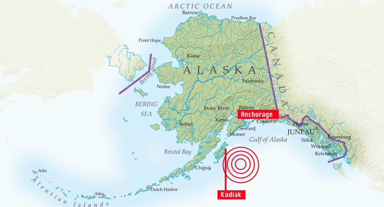
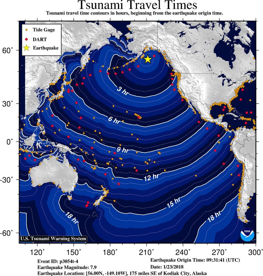